
This report is shown as scanned pages until a volunteer types it up. Skip to the machine-read text (unproofread), which a screen reader can read.
Machine-read text (unproofread)
Read from the scans by software, so it contains mistakes. Typing it up properly would help blind readers: use Suggest an edit.
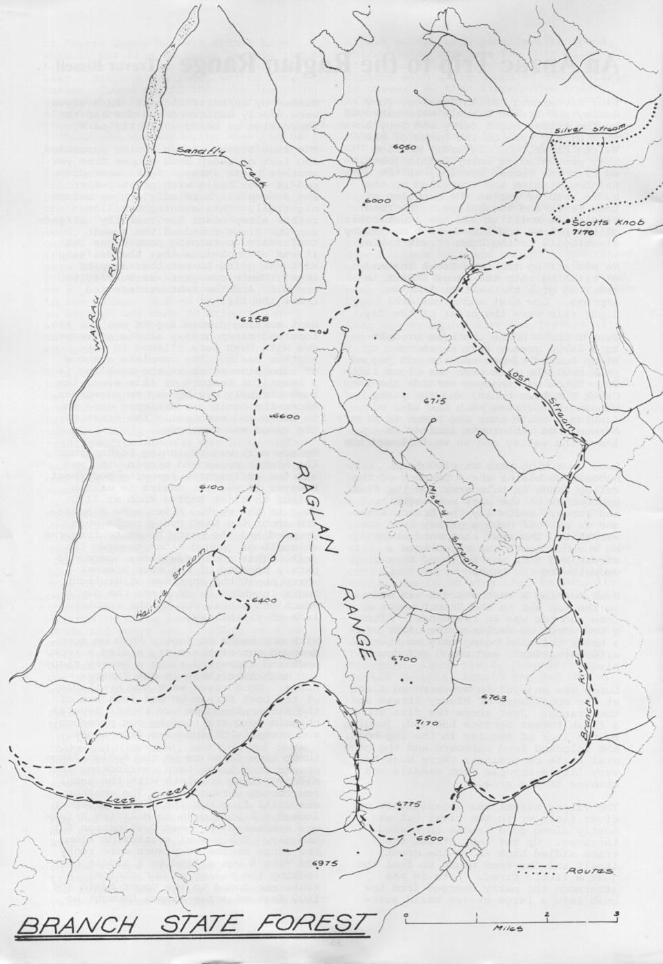
An Anzac Trip to the Raglan Range Trevor Bissell Paul Richardson, Brian Charles, Tony ounded by bushclad slopes. Bush edges Gazley and Trevor Bissell were conveyed were neatly manicured and one had the by the Friday night ferry and Tony's van impression of being in a city park. to a picnic spot on the banks of the Wairau River. On Saturday morning The side stream of our choice descended they presented an entry permit (obtain- 500 feet of steep bush slopes from yet ed from the Forest Service) at the another basin above. Packs were drop- Rainbow Station and travelled up the ped in this basin with great relief hydro road as far as the junction of and a camp was hurriedly set up before Lees Creek and the Wairau. The road nightfall. This evening the "I'd itself was built to aid the construction rather sleep under the tent fly" brigade of the pylons and lines which now carry won the first round of the summit electricity to the Cook Strait cable. conference on camping procedures but it was soon obvious that the drifting We set off up the Lees Creek instead mist was going to wet the sleeping of climbing onto the range itself in bags. Hence our gear was bundled to order to give the weather time to one side and the tent was erected improve. Low mist and occasional under the fly. light rain were the order of the day. Next morning dawned a good one for the Two or three hours upstream brought us tops and steep grassy slopes intersperto a large grassy flat surrounded by sed with bush were climbed to yet steep bushed slopes and the odd jagged another basin. The complete absence peak could be seen when the cloud lift- of subalpine scrub at the bushline is ed. Lunch was enjoyed outside the Lees a beautiful feature of this area, the Creek Hut (two bunks) and the party bush abruptly giving way to snowgrass. continued upstream with the idea of Above the basin grass slopes gave way finding a route over the Range to Misery to scree and eventually the crest of Stream. No such route invited us to the ridge was reached. leave the valley and so we followed the By now mist was beginning to enshroud Lees to a high pass at 6200 feet. the higher peaks and a cold wind was Successive basins are a feature of the all too efficiently removing body heat. valley heads in this area and the final However it was our desire to make a approaches to the pass were over rock detour to climb Scotts Knob at 7170 and scree. Below lay the Branch River feet to the east. After some discussand we set off down a grassy spur toion about the best route packs were wards it. The spur steepened abruptly dropped and the party began to traverse so a sidle route was taken into a a length of jagged ridge towards the stream and this was followed to a good peak. This route was later abandoned campsite in the bush. partly because of the ever present worry about the shortage of daylight Next morning a bush descent was made hours in which to complete the day's to the top hut in the Branch where a march and partly due to the complete lone shooter was in residence. After lack of visibility. a few words we declined the offer of a brew, the time being only an hour With our backs to Scotts Knob we soon after breakfast, and raced off down dropped out of the mist, sidled a rocky river. peak and traversed along a grassy ridge top much like those in the Tararua Lunch was enjoyed in sunshine on flats Range. Good views were now available at the confluence of Misery Stream and of the Lost Stream on our left and of the Branch. Just above the flat stood the Silverstream on our right. Several a flash Forest Service hut and, judging chamois were startled by our presence by the lack of entries in the log-book, and promptly disappeared from sight. the unlocked food cupboard and the general state of tidiness there must be Lunch time found us on the Raglan Range very little trouble from vandals and proper at a large tarn overlooking the thieves in the area. Misery Valley complete with the usual red Forest Service hut. The weather The valley travel was occasionally on was still fine but its future prospect river flats or in the river but was looked a little grim so Hellfire Stream mostly along good tracks on bushed was nominated the best destination for terraces. Up the Lost Stream the the day. The travel southwards along track sidled high above the creek the range became very much more rocky itself and the team began to feel the and Trig B was sidled to a saddle overjust a little tired. Late in the looking the valley of our choice. A afternoon the party emerged from the route was found to the upper basin and bush into a large grassy basin surr- 1500 feet of scree slopes brought us
Silvar Streom Sanafly 6050 E e PO 00 Scotts Kno4 6 7170 6258 66 00 A X I
6400 Ho 6700 I .763 recky Le 6 500 6975 Routas. BRANCH STATE FOREST Milas down to the stream. The night's camp top to be slow travel. A sidle on the site was found about a mile downriver opposite side of the ridge was found in the bush. to be necessary and a rock chimney had to be climbed to re-unite the team. Day four dawned a good one and it was decided that the ridge south of Hell- Insufficient time remained for a leisfire Stream would provide a more scenic urely lunch break so numerous handfuls route back to the Wairau Valley. A of Paul's scroggin (two kilograms were super stagger up through steep bush salted away in his pack) were consumed and a grass and scree crawl were during quick stops. By the time the rewarded by really good views. For descent down the spur to the Wairau the first time on the trip the snow River had been made enough time had covered peaks of the Inland and Seabeen gained for a half hour lunch ward Kaikoura Ranges stood out against break before we had to leave to catch a blue background. Travers, Cupola the ferry home. and Hopeless could be seen on the Travers Range and the Wairau and a number of tributary valleys were Footnote: A club party visited the identified. Raglan Range in September 1978. Three of the party (Tony, Paul and Jan Van Tony and Brian had taken a shortcut Beemen) traversed Scotts Knob from across a large scree basin, rejoining Upper Silverstream hut, while the the ridge crest further south. They other six members climbed up from were able to rest for quite some time Scott Stream, but only Paul Aubrey while Paul and Trevor found the ridge gained the summit from here.
Comments
Comments are not open yet.