
Text taken from the club newsletter.
OFF THE HEAPHY HIGHWAY
A solo journey to a hidden hut by HARRY SMITH
October 2010: I am at Gouland Downs Hut on the Heaphy Track with Jenny Cossey and a party of school students of hers who are doing the trip as part of their Duke of Edinburgh Award. We have enjoyed a pleasant night at this historic hut, my favourite on the track. Last night I went kiwi-spotting in the bush behind the hut but unfortunately failed to spot any. Today I am planning a quest of a different sort, one that I hope will prove more successful. Jenny and the others are heading through to Mackay Hut for the night but I have other plans. I remember reading about an old hut somewhere on the McKay Downs to the north of the Heaphy Track—a hut put in by the old Ministry of Works when they were investigating proposals to put a road through here from Karamea to Collingwood back in the early seventies. (This was around the time I first walked the Heaphy, and well before Jenny’s students were even born, but that fact is just too depressing to contemplate). Thankfully the road never went ahead, but the hut remained. A quick check and sure enough, I find it marked on my map, just a centimetre in from the northern edge. A passing DOC ranger confirms it is still there, and has in fact recently been done up and restored, but warns that it can be hard to find. I determine to check it out.
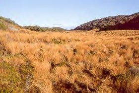
Later in the day at Blue Shirt Creek I wave goodbye to the others, turn off the benched and graded, super- smooth Heaphy Highway, and head north up a narrow, enclosed, trackless, tussock valley. Ahead the map shows an extensive area of downlands—a fascinating mosaic of shallow tussock basins and valleys separated by low, bush-covered hummocks and ridges, forming a large, flat plateau, 850 metres above sea level. This looks like interesting but potentially confusing country, like a giant jigsaw or a huge, rumpled, multi-coloured knitted quilt, and I am looking forward to the navigational challenge. By stringing together a series of linear tussock leads it looks like I should be able to follow a good ‘handrail’ route right the way to the hut.
A kilometre and a half upstream the valley opens out into a large tussock basin. The going is swampy underfoot, with a small stream meandering through peaty, marshy flats. It proves slow going as I try to avoid sinking into the mud or being forced into the scrub. Once or twice I see indications of footprints, suggesting that others have been through this way before me. They seem very recent—is it possible I will actually run into somebody at the hut ahead of me?
I climb out up the side of the basin, cross the far ridgeline, and bash down through a short section of bush before emerging out into another open tussock valley. Here I head right, but after a few hundred metres the ground begins to drop away steeply in front of me. Puzzled, I stop and check the map. This doesn’t make sense. This should be flat going. What is this stream? What are those hummocks to my left? Where is that open lead I was expecting? I am completely confused. I get my compass out and take a series of careful bearings. Nothing seems right. Then suddenly the map snaps into focus. Ah, of course! Now I see! I must have crossed the last ridgeline a few hundred metres north of where I thought I had. Now it all makes sense! I am annoyed with myself for the error but glad that I didn’t just plunge on, that I stopped and figured it out. I backtrack for a few hundred metres, then head off in the right direction, down a narrowing tussock lead.
The tussock lead opens out into a wider valley. I turn left, and after a couple of bends my route leads up a narrow, bushy gully. At the top of this I climb out over a dry saddle and down broad slopes into another narrow, tussocky valley. I follow this through a slow series of wriggly bends, criss-crossing the stream, then head north for another kilometre, climbing gradually up another widening valley towards another open saddle in the distance.
At last I reach the saddle. If my navigation has been right the hut should be only a few hundred metres away down the other side. I can see nothing. The afternoon is getting on and there is a cold wind blowing—I hope I haven’t stuffed it up. I head down the small valley from the saddle and sure enough, there is the hut, hidden from view up to the right. I have done it. It has taken me 3½ hours to travel 5 kilometres across the maze of the downs—slow going, but I have strong sense of satisfaction of having navigated successfully to my goal. I open the door and step inside. Nobody is there.
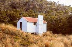
The hut is a classic old-style Forest Service six- bunker. The location is slightly disappointing, in a small, barren alcove without a view. I think I have been subconsciously hoping for a nice, smooth grassy flat and sweeping vistas. But never mind—the hut itself is neat and tidy and in good condition. It has an open fireplace, as all good huts should, and wood is neatly stacked in the porch.
I check the hut book and find that there was another party here only two days ago. They must be the ones who made the footprints I saw in the mud earlier in the day. And another party was here only a week before that! Checking the entries, it appears the hut generally only receives a handful of visits a year, often with months between them, so it seems pretty amazing that I am the third party here in little over a week! Many of the people visiting the hut are en-route to or from Kahurangi Point lighthouse down on the coast to the north. Others mention the route from Blue Shirt Creek that I have followed. The hut book goes back many years and makes fascinating reading. It seems that Arnold Heine of the Hutt Valley Tramping Club has been the main driving force behind unofficially maintaining and preserving the hut for many years before DOC finally stepped in recently and restored it. DOC wanted to remove it but were eventually persuaded to keep it because of its historical significance.
That night I enjoy a blazing fire and the comforts of a hut to myself. It’s funny, I contemplate to myself how this dot on the map in the middle of nowhere provides a target for people like me who like to visit out of the way places. The hut itself is situated nowhere in particular and serves no particular purpose. If the hut wasn’t here we wouldn’t come here. But paradoxically, by being here it attracts us to this spot and thus justifies its own existence!
Next morning I am away at 7.30, heading back to the Heaphy Track. Rather than returning via Blue Shirt Creek I decide to follow a direct route across the downlands to James McKay Hut. Again this involves navigation by map and compass across a confusing undulating landscape, following another ‘handrail’ of tussock leads amongst low, bushy hummocks. Together with my route the previous day, today’s route will form the second side of an almost exact equilateral triangle on the map, the third side being a 5 kilometre section of the Heaphy Track between Blue Shirt Creek and Mackay Hut that I will miss out.
I travel down a broad tussock valley and pass a distinctive balancing rock, before hopping up over a small sharp saddle, where I note with satisfaction a cairn on top. Others have clearly been this way before me. Beyond the saddle I emerge out into a larger valley where I am surprised to discover a series of sticks placed upright in the swampy ground, serving as marker poles, indicating the route down valley.
At 11.30, four hours after leaving the hidden hut, I finally reach a large open clearing on the ridgeline below Otepo Trig. Down the hillside before me I can see McKay Hut and the Heaphy Track. Again I have a sense of satisfaction of having successfully navigated to my goal. Tonight I will rejoin Jenny and the others at Heaphy Hut on the coast and tomorrow we will tramp out down the coast to the end of the trip at the Kohaihai Bluff, but for now I am in no great hurry to get back to civilization. Below me I can see some small stick figures milling around outside the hut. I could go down and have lunch at the hut but somehow that would seem to spoil the day. Instead I slip my pack off, sit down in a comfortable spot in the clearing, and enjoy a relaxed lunch in the sun before finally descending and rejoining the Heaphy Track.
Comments
Comments are not open yet.