
Text taken from the club newsletter.
ORONGORONGO WANDERINGS by HARRY SMITH
The Orongorongos seem to be a bit of a neglected area for Wellington trampers. On the weekends lots of day trippers, family groups, and private hut owners take the Five Mile Track into the Orongorongo Valley, but few people seem to go anywhere beyond here—more serious trampers tend to spend their weekends going to the Tararuas and other places further afield. I hadn’t been anywhere beyond the Orongorongo Valley (or indeed, hardly anywhere beyond Paua Hut) for quite a few years. In January I had some time on my hands so I decided to head into the Orongorongos for a few days mid-week when all the usual weekend visitors would be away.
Monday afternoon saw me at the Sunny Grove road end in Wainuiomata, and I had a pleasant walk in to the valley in sunshine over the Whakanui Track. There is a nice grassy clearing at the end of the track, about a hundred metres before the river, where I camped. I had plenty of daylight left so I decide to wander across the river to check out Baines, the Hutt Valley Tramping Club hut. I had visited it shortly after the big floods back in 2005 and the area around the hut had been badly affected, but the hut itself had survived. Now I was curious to see whether it had suffered any further problems in the last few years. But the whole area was virtually unrecognisable to me, despite my brief visit in 2005. Before the floods Matthews Stream used to be full of buddleia scrub and there was a track up through the bush to Baines—now the stream was a broad, open gravel highway. Gravel was spread out under the surrounding bush and Baines was nowhere to be seen! I blundered around for a while criss-crossing the area, wondering whether it was a bit further back in the bush than I remembered, but I couldn’t see any sign of it. Eventually I stumbled onto a track leading up onto a raised terrace where I came across a private hut I hadn’t previously known about.
Surprisingly, the owners were in residence and they told me the Hutt Valleys had demolished and removed Baines. The floods had left it in a precarious position, with any new floods threatening to wash right through it. The floods also of course seriously affected Waerenga Hut, the Tararua Tramping Club’s hut beside Brown’s stream opposite Jacob’s Ladder, and they ended up shifting it to a new site 100 metres back into the bush. So our own Paua Hut was the only tramping club hut to come though the floods unscathed, thanks to its fortuitous location on solid ground high above the river.
Next morning I headed up river to Boulder Creek. When I visited here after the floods in 2005 all the gravel outwash from the creek had dammed the main river and a lake had formed behind it—this was now gone, but signs of where it had been could still be seen. I boulder-hopped up Boulder Creek and set off up the Papatahi Track. This was steeper and rougher than I remembered—at one point a rope had even been put in place to help you haul yourself up a steep scree section!
Eventually I reached the top and headed off down the far side. The weather had clagged in and it was cold and drizzly and miserable, but by the time I got down to the Wharepapa River on the Wairarapa side of the ranges it had cleared up again. After lunch at Wharepapa (Joe’s) Hut I wandered down the river bed in glorious sunshine towards the coast. I camped at Ocean Beach and went in for a swim in the surf.
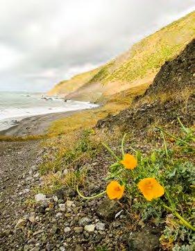
Day three was my shortest day—all of about an hour and a half! I wandered around the coast and camped in the trees between the Mukamuka and Mukamukaiti streams. This was a superb spot—the ranges rose steeply behind me and the waves rolled in on the gravel beach below me. It’s a rare chance to tramp and camp on an undeveloped coastline in this country and I’ll never tire of these Cook Strait coastlines. I spent the rest of the day wandering around the area, checking out the beach and the rocks and poking my nose up Mukamukaiti Stream. Unfortunately the four-wheel-drive hoons seem to have discovered this area since I was last here, churning up the grass terraces and leaving broken bottles strewn around.
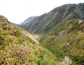
Next day I headed up the Mukamuka to cross back over the ranges via South Saddle. It must be over twenty years since I was last in the Mukamuka and I don’t remember it very well, but I’m sure it wasn’t like this! The whole valley was a broad, flat sea of gravel stretching from hillside to hillside, with all vegetation stripped away from the valley floor. Obviously the 2005 floods had hit this side of the ranges hard as well!
The valley floor provided a super-highway, a smooth escalator ascending steadily up into the ranges. As I followed upstream the hillsides closed in and I soon found myself in a narrow defile. Eventually I left the open gravel streambed to follow track markers up through the bush and tangled scrub of a narrow gully leading steeply up to the saddle, where I stopped for lunch in the sun.
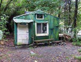
ABOVE: Bain-iti Hut Photos: HARRY SMITH
TOP: Mukamuka Stream from South Saddle
OVERLEAF: Eastern coastline
...Two paths diverged in the wood and I— I took the one less travelled by, And that has made all the difference.
Robert Frost
I had originally intended to head out over the Whakanui this day but it was so nice in the sun I decided to stay for another day. So instead of heading down I headed up to the summit of Mt Matthews. Later, back down in the valley, I checked out Bainiti Hut, across the opposite side of Matthews Stream from where Baines used to be. This is the only open hut in the valley. I was pleased to see it was still there and hadn’t suffered any damage, but with all the gravel build-up it is now only a couple of feet above the river bed, whereas I’m sure it used to be a good two or three metres! It seems safe enough at the moment but it would only take another sizeable flood and it too could be washed away.
I spend the night back at my old campsite at the end of the Whakanui Track. Next morning I decided to head out over the East Whakanui, which I had never done before. This turned out to be an excellent alternative, climbing steadily up the ridgeline past some superb giant ratas, then down through a shallow saddle before joining the main Whakanui Track. Here I decided to take the old route out via Nikau Stream rather than what is now the standard way out to Sunny Grove. This proved to be overgrown but still followable. Back in Wainuiomata I capped the trip off with a giant ice-cream before catching the bus for home. It had been an excellent five days in the local hills.
Comments
Comments are not open yet.