
Text taken from the club newsletter.
LE TOUR DE NOUVELLE CALEDONIE by HARRY SMITH
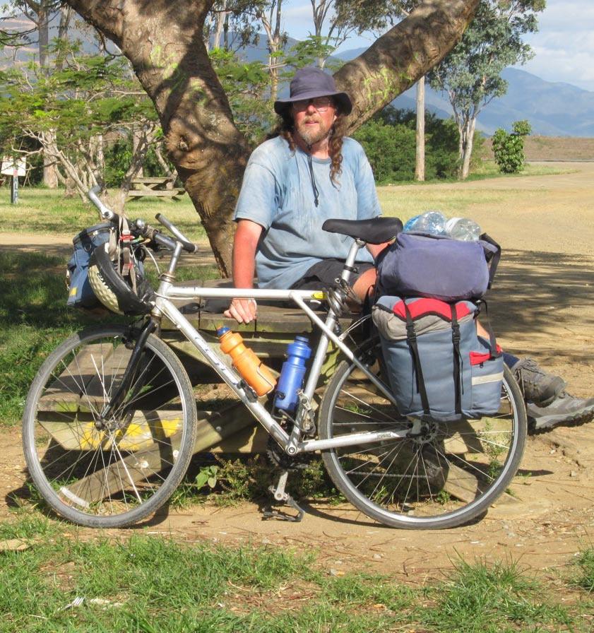
THE START I was cycling down the highway in the dark. My right hand was done up in a bandage after com- ing off my bike a few days earlier on a flat street in suburban Kilbirnie, making it awkward to operate my right-hand brakes and gears. I was on the unfamiliar, right-hand side of the road, continually reminding myself to keep right but aware that in an emer- gency my natural, instinctive reaction would be to head left, an instinct which in the current circumstances could have disastrous consequences. Huge trucks were roaring past me in the dark. I was desperately trying to find somewhere to camp but it was impossible to see anything in the darkness beyond the edge of the road. There were no streetlights and my bike lights provided only the feeblest illumination. I hoped like hell the trucks could see me. Another one roared past within a metre of me and I could hear another one coming up behind. It was bloody scary and I was bloody scared.
It was late October 2012 and I was at the start of a four-week cycle- touring trip around New Caledonia. I had arrived at Tontouta International Airport late in the afternoon. I hadn’t booked any accommodation – this was a trip on the cheap and I was planning on camping. Noumea was 40 or 50 kilometres away to the south but I wasn’t planning on going there until the end of the trip. I had set out up the highway northwards from the airport to find somewhere to camp but it had got dark earlier and more quickly than I had expected. There are actually some brilliant places to free camp in some nice clearings in the scrub within a few hundred metres of the airport itself, as I dis- covered a few weeks later, but I didn’t know that at the time. I had been naively expecting a nice, quiet road as befits a laidback tropical South Sea island paradise and had instead found myself on a busy, traffic-filled highway.
I had to get off this highway fast! I spotted a promis- ing-looking lane off the side of the road and stopped to check it out. But then I realised it was actually somebody’s driveway and decided I’d better not camp there. A bit further on I found a quarry works but decided it was too uncomfortable to serve as a campsite. And anyway, the workmen probably wouldn’t appreciate turning up in the morning to find someone asleep in their shingle pits.
After a few more scary kilometres I came to a bridge over a large river. It was one of those long, narrow bridges with high lattice sides of large steel girders – a bit like a giant cheese grater. Please don’t let any trucks come along just now, I prayed desperately as I set off across – don’t let me get cheese-grated against the side. Safely on the far side, I spotted a dirt vehicle track leading out to the right and turned off down it. I felt a sense of absolute relief, of total thankfulness. I was indescribably glad to be off the highway, to be safe and alive, out of the traffic, away from the trucks. I followed the track down to the river bank and came to a stop. This would do. I wasn’t going any further. I wasn’t going back out onto that highway in the dark, that was for sure. I hunted around with my torch and found a small clearing in the scrub where I could camp, and hauled my bike across to it. This was home for the night.
Just then a car came down the dirt road and pulled up by the river bank. I heard car doors slamming, bottles clinking, music playing. I wasn’t sure who these people were, but it was dark, I was in a strange country, and I didn’t speak the lingo. It was probably better they didn’t know I was there, so I sat quietly in my little clearing about 30 metres away, not moving or making any noise or shining a torch for a good hour or more until they went away again and I was able to get my sleeping bag out and go to bed.
All in all, it was a rather interesting and unusual intro- duction to a new country. But in the quiet of the morning I awoke to the sight of the broad river flowing lazily down from the distant mountains and gleaming silkily in the early light of dawn, and I decided this was going to be a good trip after all...
THE TRAFFIC
I packed up and headed off up the highway, and soon realised that I had seriously underestimated this trip. I didn’t have a detailed plan – you never do when you are cycle touring – but my rough idea was to do a circuit around the main island of Grande Terre, up the west coast and back down the east coast, followed by a few days in Noumea and a few days down south. I was also thinking about walking the GR1 track, a four or five day Grand Randonnee (Great Walk) in the mountains behind Noumea. I had roughly estimated that each side of the island would take me a week to cycle, including a couple of rest days. That turned out to be wildly unrealistic.
I had based my estimated distances and travel times on a small-scale map, which was all I could find before the trip. But once I arrived in the country and got a decent map, the distances turned out to be considerably bigger than I had thought. Something I thought was going to be 50 km would turn out to be more like 70. And I had naively imagined the road being flat, since it appeared to follow the coast; instead, I was met with constant ups and downs - not necessarily big climbs, just endless tiring un- dulations. And it was hot – man it was hot, with that kind of thick tropical heat which envelops you like a blanket and weighs you down and saps your energy. Small hills that I would have no trouble with at home I found myself struggling up, and I was stopping for numerous rests and going through litres of water. There were kilometre mark- ings set into the road surface and they passed by excruciat- ingly slowly.
To make it even worse, the road didn’t actually follow the coast at all but generally ran 5 or 10 km inland, fol- lowing the foot of the mountains. But the campsites were all out at the coast, so at the end of each day I had to do an extra 5 or 10 kilometres to go out to the coast to reach a campsite, often on a tiring dirt road, and the next morn- ing I would have the same 5 or 10 kilometres back inland to the highway, adding an extra 10 or 20 or sometimes even 30 kilometres to each day, on top of the distances that were already longer than I had expected anyway.
And finally there was the traffic. The traffic was un- pleasant, with cars and heavy trucks zooming past far too close for my liking. New Caledonian drivers are crazy. As
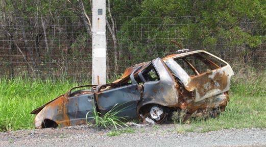
A common sight
I cycled along I passed a parade of wrecked cars beside the road, in ditches or wrapped around telegraph poles. White crosses could be seen at depressingly frequent intervals beside the road, marking the demise of some crazy motor- ist, or possibly some unfortunate foreign cyclist who just happened to be in the way. On at least two occasions cars travelling in the opposite direction to me overtook onto my side of the road, coming right towards me. Either they didn’t see me or they didn’t care. Fortunately in both cases there was a shoulder where I was able to dodge off the road; otherwise there might well have been another white cross beside the road and I wouldn’t be here to tell the story.
Towards the end of my first day a passing car stopped up ahead of me and the driver got out and waved me down. I pulled up to see what he wanted and he began babbling away at me in rapid French. My schoolbook French was decades old, and none too good to begin with, but eventually I began to make out a few words and phrases.
“La circulation!” (The traffic!), he proclaimed. “Tres mauvais!” (Very bad!). “Dangereux!” (Dangerous!).
“Grand risque!” (Big risk!), he waved his arms for emphasis. “Splat!” That one didn’t require translation. “Mort!” (Death!).
His message was clear: he was warning me in no uncer- tain terms about the dangers I faced cycling on this high- way. I had already reached the same conclusion, but what could I do? I wanted to go north and there was only one road. There was no alternative route. I agreed with him that it was risky, but I had no other choice. So I thanked him for his concern and continued on my way.
An hour later, as I was having a rest beside the road, the same car pulled up and the same man got out. This time he got out a cell phone and put me through to his sister, who spoke a bit of broken English. She explained to me the dangers of cycling on this highway and told me about some other cyclists who had been killed the previ- ous year. “Be very careful, Monsieur”, she pleaded. “It ees very dangerous, especially in ze evenings when ze sun is low and in ze drivers’ eyes.” Go over to the east coast, she urged, where it is much nicer and quieter and safer.
At this point I very nearly did decide to go over to the east coast. The traffic really was unpleasant and these people were genuinely concerned about my safety and seri- ous in their warnings. Only a few kilometres back down the highway I had passed a turnoff to one of the roads leading over to the other side of the island; I could turn around, go back, and cross over to the east coast, where everything would be better. But then I thought, if I cycle up the east coast, what am I going to do when I get to the top? I would just have to turn around and come back down again, and I really didn’t want to do that. I wanted to do a complete circuit and see both sides of the island. To cap it off, the crossing over to the east coast involved a 400-vertical-metre saddle and I just couldn’t face that at this stage of the trip. I was struggling in the heat with climbs of 20 or 30 metres. And surely the traffic must improve as I headed north, further away from Noumea, I reasoned. And even if it didn’t, I still had the option – as- suming I was still alive – of heading over to the east coast later on, over one of the other saddles further north. So again I thanked the man for his concern and decided to continue on my way.
As it turned out, the traffic did improve as I went fur- ther north, but only slowly, after a few days. The stretch of Grand Terre north of Noumea is not really a particularly pleasant place for a cycle tourist.
THE WEST COAST
I spent a week cycling up the west coast through farm- land and a succession of small farming service towns. In some ways, with the farmland, the small towns, and bush- covered hills, I could almost have been in NZ - apart from the heat, the fact that I was cycling on the wrong side of the road, and the fact that all the signs were in French. But there were some things that reminded me that I was not in New Zealand. One day I visited a restored old military fort from the 1880’s that was used to hold French criminals and as a stronghold against an uprising against the French colonists by the native Melanesians, or Kanaks. Another day I was passed by a long convoy of military vehicles. France still maintains a military presence here - it is dis- crete and largely out of sight, but it is there. Near the town
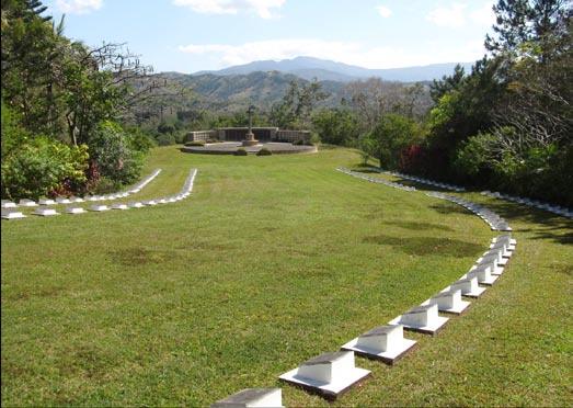
New Zealand WWII cemetery of Bourail I visited a New Zealand war cemetery from the Second World War. I have no interest in war history but it was a beautiful location and it was moving to see the rows of gravestones, still carefully tended and cared for 70 years later. There were fresh poppies on some of the graves, and many Kiwi names in the visitors’ book. My cycle-tourist eye also couldn’t help noting that it would be an excellent place to free-camp! One day I visited an idyllic hidden cove called Turtle Bay out at the coast with a superb beach and large numbers of strange, tall, thin pinetrees which are found around the New Caledonian coast. This would have also made an excellent free camping site, although I discovered it too late and had actually camped at a com- mercial beachside campground a few kilometres away!
Le Couer de Voh???
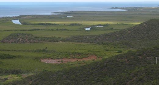
Halfway up the west coast at the town of Voh I was keen to view Le Couer de Voh (The Heart of Voh), a famous natural heart-shaped formation in the mangrove swamps. In recent years photographs of this unusual feature have appeared on pretty posters and in numer- ous books of landscape photography. There was a special lookout tower on the hill up behind the town, so I walked up there to have a look, but when I got there I couldn’t see anything. Where was Le Couer? All I could see was the swamp, the highway, the dusty town, and the local rubbish depot spread out down below me at the base of the hill - hardly an inspiring sight. The Heart was nowhere to be seen. There was no marker arrow at the lookout to indicate which direction I should be looking in, and I had abso- lutely no ideas of the scale of what I was looking for. There were one or two discoloured patches in the distant swamp which could conceivably be the elusive Couer, but none of them really seemed to fit the bill. But I took some photos of the swamp anyway, and a couple of months later, back home in New Zealand, I was able to work out where the famous Heart was in the photographs by comparing them with aerial photographs of it on the internet. It turned out it was there after all, but it appeared at such an oblique angle that it was totally unrecognizable. Despite being on top of a hill the lookout really wasn’t high enough to give you a good view - you would really have to view the Heart from the air to fully appreciate it.
I had a variety of campsites on the west coast. Most nights I enjoyed a nice campsite out by a beach. There are campsites scattered all around the New Caledonian coast, both paid ones and official free ones, and you can get an excellent free map from the tourist information offices which shows their locations. They are pretty basic but were just what I wanted. There was always a water supply and usually picnic tables and concrete fireplaces. I hadn’t brought a cooker – it was hard to find out beforehand what fuel would be available and the French have their own system of gas cookers, incompatible with our Kovea- type ones – so I was cooking on open fires, and generally this was no problem. Sometimes I had to scrounge around a bit to find enough firewood, but I discovered dead palm- tree fronds burn extremely well, although unfortunately they don’t last very long so it was necessary to gather a large supply.
Occasionally I free-camped away from the official sites. One afternoon I reached the top of a big saddle and was feeling so knackered I didn’t think I could go on. I was aiming for a campsite out by a beach but it was still 30 kilometres away and I didn’t think I could make it. Just off the road at the top of the saddle was a large white deserted concrete building, a water-pumping station or something, so I jumped the fence and camped around the back of it. A few days later towards the top of the west coast at Koumac I camped a few kilometres inland at a reserve by some limestone caves. This was completely free of the mos- quitoes which were found at many of the campsites by the coast and it was luxury to be able to walk around in the evening without getting bitten to pieces! In contrast, near Ouegoa at the top of the island the mosquitoes were so bad that all I could do was retreat to my tent at nightfall and not even think of getting out again until morning!
THE NORTHERN EAST COAST
After Koumac I headed inland across the island, up over the steep Col d’Amos, and down to the east coast. The east coast was quite different from the west coast. As I descended down from the Col I was greeted with the sight of tropical vegetation, coconut palm trees, and white sandy beaches. Yes! This is what tropical island paradises are supposed to be like! I soon found a nice deserted beach and stopped for lunch and a swim.
I spent the next four or five days cruising south along the northern east coast. This was definitely the nicest, most relaxed part of the whole trip. The roads were deserted and largely flat, and generally stuck close to the coast. Coco- nut palms arched up overhead. Rugged mountains rose up steeply behind the narrow coastal plain, or sometimes straight from the water’s edge. I crossed several large rivers on long bridges and passed a number of impressive large waterfalls tumbling down out of the hills. There was one large river that wasn’t bridged, so I crossed it on a car ferry.
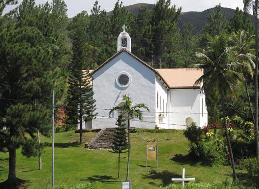
On the way down the coast I passed a number of old historic churches and Catholic missions dating back to the middle of the 19th century. One at Ballade had an impres- sive set of stained glass windows depicting scenes of the arrival of the first missionaries.
Catholic church
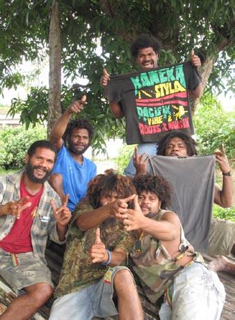
Unlike the west coast, where the population was mainly made up of Caldoches, or white New Caledonians, the people on the east coast were mainly Kanaks, or native Melanesians, and the Kanak culture was strong. Most seem to live a fairly basic, subsistence lifestyle, growing crops or fishing. I passed a number of roadside stalls selling fruit and vegetables, flowers, shells, and soapstone carvings. Signposts pointed to Kanak tribus or tribal areas inland up valleys and in the mountains. The Kanak women all wore long, loose, colourful “mission dresses”, so called because they were introduced by the Catholic missionar- ies in the 19th century who were shocked to discover that in this tropical heat the natives quite sensibly preferred to go around au naturel. Lonely Planet describes them as “Mother Hubbard dresses” and they have in effect become the national costume of the country.
There were signs of a strong independence movement everywhere on the east coast. The multi-coloured Kanak flag could often be seen, and portraits of Che Guevara and slogans calling for an independent country of Kanaky could be found scrawled over bus shelters and bridges.
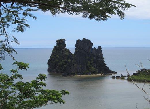
Halfway down the northern east coast I came to one of the most famous landmarks in the whole of New Caledo- nia – the limestone cliffs and rock formations around the small town of Heingeine. Here a broken band of upturned limestone rock stretched across the mouth of a large bay. On the northern side of the bay it formed a limestone island called The Sphinx which bore a strong resemblance to the ancient Egyptian monument, while on the southern side another even more famous rock island known at Le Poullet or the Brooding Hen looked for all the world like a giant chicken. Further south, I stopped for lunch where some huge limestone cliffs towered up over a beautiful palmtree-fringed lagoon.
The Brooding Hen (Le Poulet)
To the south of Heingene I visited a Kanak cultural centre with traditional Kanak carvings and fares, or thatched conical huts. On the wall of one building was a large mural depicting a number of Kanak heroes from the independence unrest back in the 1980s, including Eloi Machoro, the Kanak Che Guevara, who was gunned down in a hail of bullets by the French para-military forces when he was involved in the occupation of a mining town, and Jean-Marie Tjibaou, the greatest Kanak leader of all, who was assassinated shortly after signing an agreement with the French in 1988 to put an end to the violence. When I first read about this I assumed it was done by pro-French extremists, but no, it seems it was actually done by other Kanaks. I don’t know the full history behind this but I think they must have thought he was selling out.
Further down the highway I stopped for a rest outside a school and was invited in for a meal by the Kanak teach- ers. With roast chicken and pork, fried fish, rice, taro, and kumara it was probably the best meal I had on the whole trip, and it made a nice change from my stan- dard meals of dehy potato and tuna, or canned ravioli! For some reason the grocery stores in New Caledo- nia have whole shelves devoted to vast quanti- ties of canned ravioli at dirt- cheap prices, which makes it a perfect meal for budget- conscious cycle tourists! One of the teachers spoke a bit of English and we talked about the New Caledonia and the Kanaks and the different Kanak languages spoken there. I mentioned I had visited the cultural centre and seen the mural of Jean-Ma- rie Tjibaou, and this made them happy. One of them gave me a cigarette lighter in the Kanak colours as a souvenir, and later another one gave me the t-shirt off his back, which featured a Kanak slogan! This is the great thing about cycle touring – things like this just wouldn’t happen if you were travelling around by hire car and staying in fancy hotels! As a poor cycle tourist they clearly regarded me as sympathique (which I was).
Kanaks
I enjoyed a range of beach-side campsites down the east coast. Two in particular stand out. One was an abandoned old campground just north of Touho where you were allowed to camp for free. There were picnic tables and fireplaces scattered around a grassy field, but the grass was overgrown and there was no water in the taps. The camp- site was located down a side-road beside a quiet estuary, and through the trees was a nice little hidden sandy beach.
By this stage I had been going 10 or 12 days in a row and felt like I could really do with a rest day. I had had a couple of half rest-days but no full ones. This was an excellent spot - apart from the lack of water. I was carry- ing enough water with me to last for one night but not for two. I tried all the taps but there was nothing. In the morning I reluctantly packed up and was about to head off. I walked down to the estuary to have one last look around, and when I came back to my bike I suddenly noticed water gushing out of one of the taps! And when I tried the others there was now water in them as well! Somebody must have seen me and turned the water on for me! That was it! I unpacked, put the tent back up, and spent the rest of the day relaxing, lazing in the sun, swim- ming in the estuary, sunbathing on my little hidden beach, and drinking endless cups of tea. This turned out to be the only full rest day I had on the whole trip until I got into Noumea. So much for my original over-optimistic plan of a rest day every three or four days!
The second memorable campsite was at a place called Tikan. Tikan campsite was amazing. Beautiful mown grass stretched out under palm trees for hundreds of metres along the coast, studded with fireplaces, water taps, and thatched fares for shelter. And all for the absolutely dirt cheap price of four New Zealand dollars a night, which you paid with an honesty system at the farmhouse across the other side of the highway. Amazingly, it was nearly completely deserted, with only one or two other groups camped there.
Even more amazingly, it had a hot shower, a Heath Robinson contraption fuelled from a large gas cylinder. This was unbelievable luxury! None of the other campsites I stayed at had a hot shower, not even the more com- mercial ones. This shower was even mentioned in Lonely Planet, and I had been looking forward to it for days. I set up camp and cooked dinner, intending to check out the shower later in the evening. But then I got invited by a French couple over to their campfire and we got talking about their travels. They had a bottle of nice French wine, the conversation flowed…..and when I finally stumbled back to my tent in the early hours of the morning I had completely forgotten about the hot shower. Next morning I packed up and set off, and it was only when I was about twenty kilometres down the highway that I suddenly remembered it. Damn!
THE MOUNTAIN
Halfway down the east coast I entered a black hole. The Lonely Planet guidebook has sections describing the northern east coast and the southern east coast, but there is a gap in the coverage in between. I soon discovered why. The map showed the road going inland, and it was clear that it must go through some hills. What I wasn’t expect- ing was that it climbed right over a mountain.
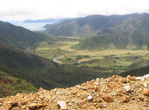
I was cycling along beside the sea when the road began to climb. It wound its way up through a huge open-cast mining area. Eventually the road crested the ridgeline and began going down the other side. I thought I must have reached the top, but I was wrong. The road did go down the other side - for about 50 vertical metres or so, then it levelled off and began sidling around the hillside, and then it began climbing once again. It kept going up and up and up. I passed through an altitudinal zone of unusual pine trees, which I read later was an alpine species, and found myself up in the clouds!
View of the coast from mountain road
Eventually the road flattened off and I reached the top. I’m not sure how high this climb was - it’s not mentioned in the guidebook and my map did not have any contours or spot-heights, but my guess, based on how much I climbed and what it looked like looking back down, it that it was probably 700 to 800 metres above sea level. By way of contrast, the top of the Rimutuka Hill Road north of Wellington is 550 metres above sea level, and that doesn’t actually start at sea level, so this was a big climb and I was glad to finally reach the top. But I’m glad I did this in the direction that I did, from north to south, because the road at least wound up over quite a few kilometres and was ba- sically rideable, whereas the other side just plunged down. It dropped down so steeply into the valley below that there was no way I would have been able to ride up it – I would have been off walking and pushing the bike the whole way.
This was the most wild and remote part of New Cale- donia I passed through. There were no towns or villages this day, very few if any farms, and virtually no traffic the whole day. I stopped for lunch and a swim in the river in the valley floor, but what was worrying me was that, from the map, it looked like I may have to go over an equally big hill on the other side of the valley in the afternoon! As it turned out, I did go over some more hills but they were nowhere near as large. I emerged out into another remote, deserted valley which led me back out to a sizeable town and mining port on the coast.
THE SOUTHERN EAST COAST
The southern east coast felt quite different from the northern east coast. It seemed more scrubby and barren, and the hills were heavily scarred by mining operations. There were several small mining towns by the coast with the road going inland between them, up valleys and over saddles, which was hard work on the bike.
On my last day on the east coast I passed over a 400- vertical-metre saddle. The road was narrow and winding and unsealed, with vertical drops off the side in places. This would be a very dangerous stretch of road, so an unusual one-way system has been put in place to deal with it. It takes about half an hour to drive through from end to end, and traffic is only allowed in one direction at a time. Traffic heading south is only allowed to enter during the first 20 minutes of even-numbered hours, and traf- fic heading north is only allowed to enter during the first 20 minutes of odd-numbered hours. I had been warned that this could be a dangerous road on a bike, but in fact it worked out perfectly. I set off from the northern end shortly after all the other traffic had left, so I had the road completely to myself. It took me nearly hour just to get to the halfway point at the top of the saddle. Here I sat and waited for the traffic to come through from up ahead, and when that had all passed by I set off down the far side, safe in the knowledge that there would be no more traffic com- ing through from ahead and that it was still too early for the next batch of traffic to catch up with me from behind. I reached the far end without encountering a single car the whole way. I was off the dangerous section of road, relaxing by the river in the valley, when the next lot of cars came through from the rear.
NOUMEA
I spent my last night on the east coast at a nice palm- tree-fringed campground south of the mining town of Thio. Next day I cycled back across the island over a 400- vertical-metre saddle and the following morning I cycled south to the airport at Tontouta, nineteen days after I had left it. From the airport I got a bus into Noumea. There was no way I was going to cycle into Noumea itself with all the crazy New Caledonian drivers! And anyway, the highway turns into a motorway south of the airport, and it would have been a complete nightmare trying to find my way into the city on the confusing suburban backroads.
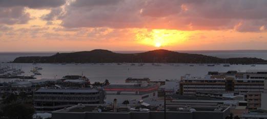
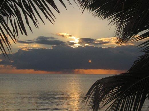
Noumea sunset
Noumea was a nice place – a small city, but definitely a city and the only one in New Caledonia (the next biggest centre is only about the size of Waikanae.) It was typically French, with a large central square and a large cathedral overlooking the town centre on the hillside above. There was even a Latin Quarter, or at any rate a separate subur- ban district which rather grandiosely went by that name. Policemen rode around on bicycles, cruise ships disgorged tourists at the wharf, and people played boules in the tree- lined square. Old Kanak women walked around in their mission dresses, while hip younger ones wore designer jeans. Sporty locals biked or jogged around the waterfront, luxury yachts packed the marinas, and luxury, five-star, high-rise hotels full of rich tourists overlooked the beach at Citroen Bay. On the hill overlooking the cathedral was the youth hostel, the only one in New Caledonia, where I stayed for two nights.
THE FAR SOUTH
By this stage I had abandoned my plan to walk the GR1 track. My bike circuit around the island had taken longer than expected and I no longer had the time – or the enthusiasm, with the heat and the hills. But I still had a few days to spare before I was due to fly home so I decided to get the bus down south to see the southern end of the island and visit the Parc Provincial de la Riviere Bleue, New Caledonia’s premiere national park.
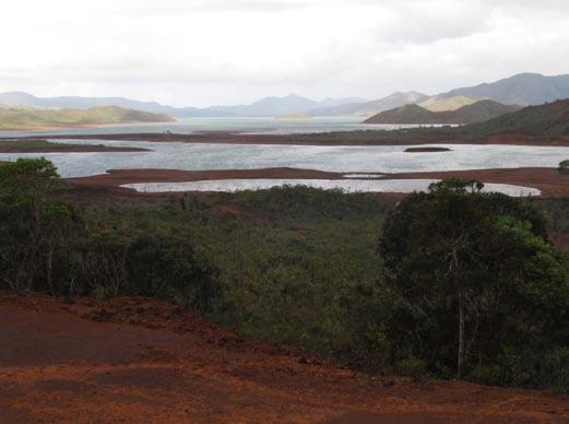
The southern end of Grand Terre is a strange landscape of reddish, mineral-rich soils and shrubby, stunted veg- etation. The park encompasses the forested valleys at the head of a huge man-made reservoir occupying the central valley floor – a barren landscape of bare red earth, cracked red mudflats, and the stark skeletons of drowned forests. Some people may consider this a scene of devastation and destruction, but I found it a landscape of strange, austere beauty. The barren expanses and harsh reddish colours give it a surreal, alien feel, as though you have been mysteri- ously transported to the surface of Mars.
Parc Provincial de la Riviere Bleue
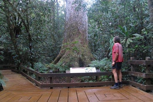
You need a permit to camp in the Park, but it is a mere formality at the park entrance. From there a road winds up the valley beside the upper reaches of the reservoir until you come to a bridge over the river. Cars have to stop here, but walkers and cyclists can continue beyond this point. I cycled up the road and unexpectedly found myself in kauri forest! This was a complete surprise! I had thought kauri was a uniquely New Zealand tree, but no, it turns out there are several species here in New Caledonia, as well as species in Australia, New Guinea, and Indonesia. Just like in New Zealand, most of New Caledonia’s kauri forest has been milled, but I stopped off at one huge specimen which was thought to be the largest remaining kauri tree in the country.
New Caledonia’s biggest kauri tree
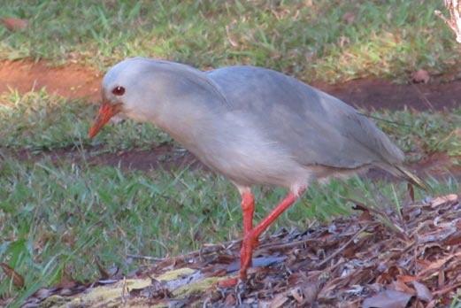
A cagou
In the evening I saw three strange greyish-white birds wandering around my campsite. These large flightless birds are called cagous and are the New Caledonian equiva- lent of the kiwi in New Zealand. They are a symbol of the country and the name is applied to New Caledonian sports teams. I wasn’t expecting to see any cagous - they have been affected by introduced predators, just like our birds, and are now rare. I had also read that they were shy and retiring. I don’t know about shy and retiring – the three I saw wandered around my campsite completely unconcerned, as if they owned the place (which in a way I suppose they do).
Cagous are famous for their unusual call. This is commonly described as sounding like a dog’s bark, but it didn’t really sound like that to me. To me it seemed more like a whirring, mechanical sound, a bit like an old, hand-pushed lawn-mower. It would accelerate up, then whirr away, then decelerate to a stop.When I first heard it
Tropical paradise
I looked around, thinking rather improbably that some- body must be mowing the grass in the campsite where I was staying. And even when I figured out that it was the cagous, every time I heard it I would still instinctively look around for the lawn-mower!
Another famous New Caledonian bird I saw was a New Caledonian crow. These are the only birds in the world, and one of the few animals of any sort, which make tools. They break and fashion twigs which they use to extract grubs and worms from holes in trees and rotten logs. Tool use is a sign of intelligence, so these are quite possibly the most intelligent birds in the world.
After two nights in the park I got the bus back into Noumea, where I spent another couple of days looking around and checking out the beaches, the museum, the cultural centre, and other sights. My last night was spent camping in the bushes outside the airport before getting my early morning flight for home the next day.
I enjoyed my trip cycling around New Caledonia, but it definitely proved tougher than I had expected, even though I wasn’t doing particularly big days. It was much hillier than I expected, and the heat definitely took its toll. But it is still a fascinating country to visit and an excellent place to go cycle touring (even allowing for the crazy driv- ers and the traffic north of Noumea). The northern east coast in particular is superb. If you had a month to spare you could cycle right around the island like I did, but even if you only had a week you could do a great trip. Catch a bus up north and spend four or five days cruising down the northern east coast before getting a bus back down south, and finish off with a few lazy days in and around Noumea. New Caledonia is our closest neighbour (it’s actually slightly closer than Australia) but sadly not many kiwis ever seem to go there.
Comments
Comments are not open yet.