
This report is shown as scanned pages until a volunteer types it up. Skip to the machine-read text (unproofread), which a screen reader can read.
Machine-read text (unproofread)
Read from the scans by software, so it contains mistakes. Typing it up properly would help blind readers: use Suggest an edit.
Backpacking in the Cordillera Blanca Clare Kempster isiting New Zealand and the than the Cordillera Blanca, but with other side. This area of Peru has been WT&MC last Xmas inspired no permanent snow or glaciers. At subject to lots ofe fearthquakes-the last me to write about a trek I did about 5pm we reached a flattish shoul- big one was in 1970 and destroyed in South America en route home to der, with views over a steep-sided can- many of the towns along the valley. Pommie-land. yon toMulluacocha (5, 480m), the first snowcapped peak of the Cordillera We traversed along the river until it Whilst deciding where else to visit in Blanca to come into view. plunged into the Mayabamba Valley, Peru before crossing to Ecuador, Ispotand we made a gradual ascent to the ted the description for Huaraz in my The next day was a little cloudy as we next pass (4,500m). No icy wind on guidebook-"popular with hikers and continued to wind our way upwards this one, So we stopped to admire the al Mecca fori international climbers"- past the dammed Lake Cullicocha, views ahead to Lake Safuna and the: 3 I knew I had to go and check it out. with lovely views of the 3 glaciated peaks of Pucajirca before droppinginto Nestled in a valley (at 3,090m) it is peaks ofSanta Cruz. We gained height the Tayapampa Valley. surrounded by mountains-the Cor- steadily until we made it to the first dilleras Blanca, Negra, and Huay- and highest pass of the circuit There had been an icy wind in the night huash, and includes Huascarân, Peru's (4,850m). We'd both been at altitude So we stayed in our sleeping bags unhighest mountain (6,768m). on and off for a while, So we had no til the sun reached the tent. We folacclimatisation problems-Peru, Bo- lowed the valley towards the village Gary, an American staying at the same livia and Ecuador are perfect in that of Huillca before tackling the steep hostel as me, was planning to do an many of the cities and towns are high ascent to the next pass (4,600m). We unfrequented 8-day circuit, rather than enough that you can be acclimatizsing had a well-earned lunch break lookone of the "standard" treks. Ireckoned whilst sitting in a café! ing back over the valleys we'd come that 8 passes between 4,400m and out of to Champara (5,450m), a peak 4,850m would give some awesome Maybe it was starting uphill straight on its own just outside the Huascaran mountain views, SO I decided to join after lunch, but the ascent to the next National Park boundary. him. We pooled resources and decided pass (4,750m) seemed like hard work. to take Gary's wigwam flysheet, rather It was a nice contrast to drop steeply After a steep descent, we eventually than my tent. Peru and Bolivia have into the Alpamayo Valley where we reached Lake Sactaycocha, but the inverted seasons with rain (and snow traversed beside the river for a while path wasn'tso distinct on this side, so higher up) in the summer, and sunny until we found a good campsite with we took the best line until we picked days, but cold nights in winter. We views of more snowy peaks and gla- it up again for another steep descent packed gear in case the weather turned ciers. Incredibly peaceful; we seemed into the Jancapampa Valley. We chose bad, as mountains tend to create their to have the whole valley to ourselves. a campsite just before we reached the own weather patterns. valley floor as this valley seemed rela- We woke the next morning to clear tively populated, compared to the pre- We caught an early bus from Huaraz blue skies. We were in no rush to get vious ones and we thought it better to to Caraz and got a ride in a pickup moving as we'd decided to take ad- keep out of sight of inquisitive eyes. truck from there to Hualcayan, a small vantage of the fact we'd saved a day village at the foot of our climb up to at the beginning and take a rest day Another reasonably early start-not the first pass, saving us a day's walk before tackling the next big pass. We too hard to achieve as, after huddling along the valley. Itwas a very interest- walked for a few hours following the round a candle when it gets dark and ing ride with frequent stops to drop river to the end of the valley and set cools down, early nights become quite people off and pick others up. We were up camp. We hadn't seen anybody a habit. We chatted to a few locals as also the travelling shop, selling bread, since we left Hualcayan, but just in we passed the village of Pishgopampa. tomatoes, oranges and fish, and buy- case, we took turns watching the gear There were quite a few Indians farming maize and wheat. We eventually whilst the other went off exploring the ing in this valley, their houses and arrived at Hualcayan which is situated nearby Lake Jancarurish, fed by a wa- fields perched on the valley sides. on a fertile plateau high above the val- terfall sliding spectacularly down a Spanish (or Castellano as the Latin ley floor, yet still about 2,000m below granite face from the glacier above. American variant is known), is their our first pass. From our campsite, the famous peak second language, as they primarily of Alpamayo (5,947m) was peeping speak Quechua here (the language of The afternoon was spent following the out from behind a granite massif. the Incas) or this region's variation of switch-back trail up the side of the it. Luckily my optimistic guess as to valley with beautiful views down to the Invigorated by our rest day, we set off where the path to the next pass left patchwork of fields on the plateau and at 7am the next morning. The wind the valley turned out to be correct, but the Santa River far below, and a back- was icy, so after a quick look back at the gentler incline meant the climb drop of the Cordillera Negra-a par- the Alpamayo Valley, we dropped went on longer, so we boosted our allel mountain range, slightly lower down into the U-shaped valley on the energy halfway by chewing coca TRAMPING & MOUNTAINEERING 1996
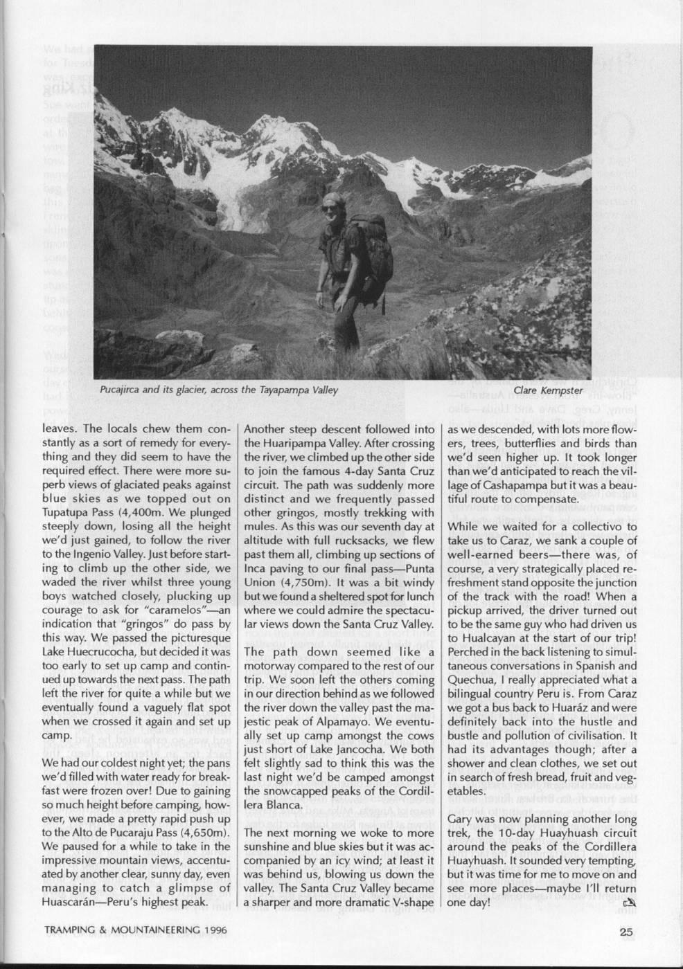
Pucajirca and its glacier, across the Tayapampa Valley Clare Kempster leaves. The locals chew them con- Another steep descent followed into as we descended, with lots more flowstantly as a sort of remedy for every- thel Huaripampa Valley. After crossing ers, trees, butterflies and birds than thing and they did seem to have the the river, we climbed up the other side we'd seen higher up. It took longer required effect. There were more su- to join the famous 4-day Santa Cruz than we'd anticipated to reach the vilperb views of glaciated peaks against circuit. The path was suddenly more lage of Cashapampa but it was a beaublue skies as we topped out on distinct and we frequently passed tiful route to compensate. Tupatupa Pass (4,400m. We plunged other gringos, mostly trekking with steeply down, losing all the height mules. As this was our seventh day at While we waited for a collectivo to we'dj just gained, to follow the river altitude with full rucksacks, we flew take us to Caraz, we sank a couple of to thel Ingenio Valley. Just before start- past them all, climbing up sections of well-earned beers-there was, of ing to climb up the other side, we Inca paving to our final pass-Punta course, a very strategically placed rewaded the river whilst three young Union (4,750m). It was a bit windy freshment stand opposite thej junction boys watched closely, plucking up but we found a sheltered spot for lunch of the track with the road! When a courage to ask for "caramelos"-an where we could admire the spectacu- pickup arrived, the driver turned out indication that "gringos" do pass by lar views down the Santa Cruz Valley. to be the same guy who had driven us this way. We passed the picturesque to Hualcayan at the start of our trip! Lake Huecrucocha, but decidedi it was The path down seemed like a Perched in the back listening to simultoo early to set up camp and contin- motorway compared to the rest of our taneous conversations in Spanish and ued up towards the next pass. The path trip. We soon left the others coming Quechua, I really appreciated what a left the river for quite a while but we in our direction behind as we followed bilingual country Peru is. From Caraz eventually found a vaguely flat spot the river down the valley past the ma- we got a bus back to Huaraz and were when we crossed it again and set up jestic peak of Alpamayo. We eventu- definitely back into the hustle and camp. ally set up camp amongst the COWS bustle and pollution of civilisation. It just short of Lake Jancocha. We both had its advantages though; after a We had our coldest night yet; the pans felt slightly sad to think this was the shower and clean clothes, we set out we'dt filled with water ready for break- last night we'd be camped amongst in search of fresh bread, fruit and vegfast were frozen over! Due to gaining the snowcapped peaks of the Cordil- etables. sO much height before camping, how- lera Blanca. ever, we made a pretty rapid push up Gary was now planning another long to the Alto de Pucaraju Pass (4,650m). The next morning we woke to more trek, the 10-day Huayhuash circuit We paused for a while to take in the sunshine and blue skies but it was ac- around the peaks of the Cordillera impressive mountain views, accentu- companied by an icy wind; at least it Huayhuash. It sounded very tempting ated by another clear, sunny day, even was behind us, blowing us down the buti titwas time for me to move on and managing to catch a glimpse of valley. The Santa Cruz Valley became see more places-maybe I'll return Huascaran-Peru's highest peak. a sharper and more dramatic V-shape one day! B TRAMPING & MOUNTAINEERING 1996
Comments
Comments are not open yet.