
This report is shown as scanned pages until a volunteer types it up. Skip to the machine-read text (unproofread), which a screen reader can read.
Machine-read text (unproofread)
Read from the scans by software, so it contains mistakes. Typing it up properly would help blind readers: use Suggest an edit.
Wangapeka Wandering Nick Wood, Jane Loughnan & Nola Urquhart On the Thursday night before Waitangi Weekend we found ourselves at the Rolling Junction shelter at the eastern end ofthe Wangapeka Track. We'dallowed ourselves 4 daysto follow, "more or less' ", the Wangapeka Track to Karamea; "more or less' l because we'd planned to take a couple oft tops diversions from the main valley route. n fact, we thought we would start off with a bit of a ther 300m to the bushline was easily gained. The poled diversion. The track marked on the Topo map up route then sidled around, skirting thel highest points and Gibbs Creek had been downgraded to a route on the was reasonably easygoing, although Jane did manage a Park map but we thought we'd try our luck heading up perfectly executed face-plant, collecting an impressive there onto the tops and over towards Kiwi Saddle Hut, bruise on her forearm, the (physical and psychological) with perhaps a look at Mt Patriarch on the way. Indeed scars of which she still bears today! On the tops, high there was a route, buti it was heavily disguised in places. cloud had drifted in and it was a bit cooler but we were The map seemed to show ther route following the creek still able to get good views toward the upper reaches of closely before climbing out of the valley to the north- the Karamea River valley and Mt Kendall. west. The path of least resistance seemed to be the On the map the route to Luna Hut looks like a steep streambed, SO up we went trying to keep an eye out for but steady 800m descent, which is probably the underany route markers heading up to the true right. On and statement of the trip. The first 500m descend through up we went with no: sign of a way out. The valley started open bush and the going is good. Part way down, after to close in and the going became tougher in the Shona lost her footing a couple of times, it was time to streambed. help her adjust her pack. I had wondered why her pack We persevered but finally after 3 hours we realised had always been angled sharply to one side. Tightening that there was little chance of re-gaining the route and the straps does wonders sometimes. even if we did, we wouldn't be able to get up over the We were in for a big surprise as the route literally fell tops to Kiwi Saddle Hut before dark. Disgruntled, we into a very steep and gorgy creek, with little to hold trudged back down to the main track, having spent about onto except cutty grass. A tricky and tiring 300m and 51 hours on a wild goose chase. 1% hours later, we were relieved to reach the river flats To console ourselves we found a great swimming hole around Luna Hut. The Karamea River was equally as in the Wangapeka River. The river was refreshing and nippy as the Wangapeka had been that morning but a the sun an invitation to expose some white flesh and quick dip was great after the exertions of the day. The relax for a while. The track is generally well-maintained hut was grotty and smelly SO we set up camp for the and easy walking, but our legs were tired from the day's night beside the river. The sandflies were a bit stroppy earlier adventures SO after passing the remains of Kiwi but most of them targeted Jane fortunately for the Shelter we straggled into Kings Creek Hutl hot and tired. rest of us. The hut was in good condition and had lots of space, The next morning took us past Trevor Carter Hut, less which our party of four and another couple easily man- than a kilometre away but much tidier than Luna Hut. aged to occupy. The path back up to the main Wangapeka Track was The next day we started off following the main damp and overgrown, but once on it we made good Wangapeka Track, staying close to the river. It was an- time to Taipo Hut. This hut is in excellent condition and other good day and by mid morning when we reached would be worth a stop if time permitted. From here we Stone Hut it was already hot. A quick dip in the river climbed up to the second major saddle, Little Wanganui proved to be a lot cooler than the day before, but worth Saddle, at slightly over 1100m. it nevertheless. The two young guys we came across at The climb is steady with a short steep section before Stone Hut were obviously avant-garde in the tramping Stag Flat, an attractive grassed open plateau with a small fashion department, both wearing full length overalls. hut, which would also be a good place for a longer stop. guess they were doing their bit to reduce the skin can- The weather was high overcast and it wasn't particucer statistics. larly warm, So after a quick lunch we continued up to From the hut, the track started to climb, gradually at the saddle, a further short but steep climb. Crossing the first but becoming increasingly steep. In all, it was a saddle literally gave thet feeling of having arrived on the 300-metre climb up to Wangapeka Saddle, where we West Coast, with the Little Wanganui River stretched stopped for lunch. The bush cover was good so that the out before us leading to the coast. The saddle is also the humidity had us drenched in sweat at the top. border between the Westland and Nelson DOC con- From Wangapeka Saddle we had decided to try an- servancies. The lack of funds available to the Westland other one of our diversions, following the well marked conservancy was markedly apparent, as the contrast to route up over Biggs Tops and over to Luna Hut. This thel high standards of track maintenance and signage up time we had no problem finding our way and the fur- until that point couldn't have been greater. Tramping and Mountaineering 1998
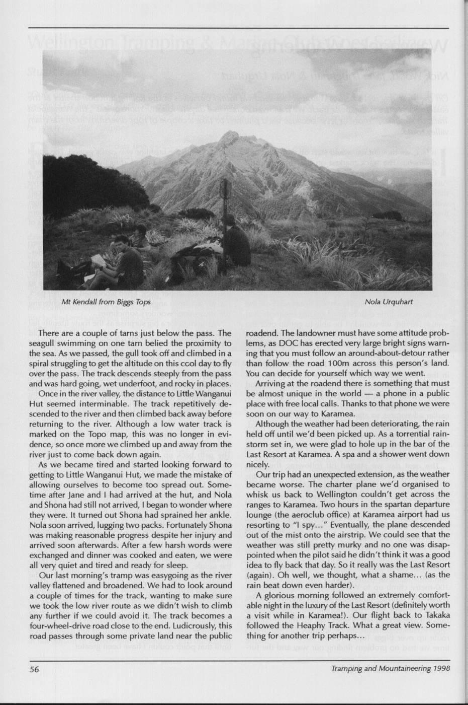
Mt Kendall from Biggs Tops Nola Urquhart There are a couple of tarns just below the pass. The roadend. The landowner must have some attitude probseagull swimming on one tarn belied the proximity to lems, as DOC has erected very large bright signs warnthe sea. As we passed, the gull took off and climbed in a ing that you must follow an around-about-detour rather spiral struggling to get the altitude on this ccol day to fly than follow the road 100m across this person's land. over the pass. The track descends steeply from the pass You can decide for yourself which way we went. and was hard going, wet underfoot, and rocky in places. Arriving at the roadend there is something that must Oncei in the river valley, the distance to Little Wanganui be almost unique in the world a phone in a public Hut seemed interminable. The track repetitively de- place with free local calls. Thanks to that phone we were scended to the river and then climbed back away before soon on our way to Karamea. returning to the river. Although a low water track is Although the weather had been deteriorating, ther rain marked on the Topo map, this was no longer in evi- held off until we'd been picked up. As a torrential raindence, so once more we climbed upand away from the storm set in, we were glad to hole up in the bar of the river just to come back down again. Last Resort at Karamea. A spa and a shower went down As we became tired and started looking forward to nicely. getting to Little Wanganui Hut, we made the mistake of Our trip had an unexpected extension, as the weather allowing ourselves to become too spread out. Some- became worse. The charter plane we'd organised to time after Jane and I had arrived at the hut, and Nola whisk us back to Wellington couldn't get across the and Shona had still not arrived, began to wonder where ranges to Karamea. Two hours in the spartan departure they were. It turned out Shona had sprained her ankle. lounge (the aeroclub office) at Karamea airport had us Nola soon arrived, lugging two packs. Fortunately Shona resorting to "I spy.. Eventually, the plane descended was making reasonable progress despite her injury and out of the mist onto the airstrip. We could see that the arrived soon afterwards. After a few harsh words were weather was still pretty murky and no one was disapexchanged and dinner was cooked and eaten, we were pointed when the pilot saidi he didn't think it was a good all very quiet and tired and ready for sleep. idea to fly back that day. So it really was the Last Resort Our last morning's tramp was easygoing as the river (again). Oh well, we thought, what a shame... (as the valley flattened and broadened. Wel had to look around rain beat down even harder). a couple of times for the track, wanting to make sure A glorious morning followed an extremely comfortwe took thel low river route as we didn't wish to climb able nighti in thel luxuryof the Last Resort (definitely worth any further if we could avoid it. The track becomes a a visit while in Karamea!). Our flight back to Takaka four-wheel-drive road close to the end. Ludicrously, this followed the Heaphy Track. What a great view. Someroad passes through some private land near the public thing for another trip perhaps... Tramping and Mountaineering 1998
Comments
Comments are not open yet.