
Text taken from the club newsletter.
IN THE FOOTSTEPS OF RHYAR MHIST
The tale of a hazardous journey through an uncharted countryside by OTYN LAYZEG
...Entered a narrow chasm. The brook and road Were fellow travellers in this gloomy straight, And with them did we journey several hours At a slow pace. The immeasurable height of woods decaying, never to be decayed, The stationary blasts of waterfalls, And in thee rent at every turn Winds thwarting winds, bewildered and forlorn The torrents shooting from the clear blue sky, The rocks that muttered close upon our ears, Black drizzling crags that spake by the wayside As if a voice were in them, the sick sight And giddy prospect of the raving stream, The unfettered clouds, and the regions of the Heavens, Tumult and peace, the darkness and the light--
As far as weekend tramping adventures go they don’t get any more dramatic than that recorded in the 2011 WTMC journal by that renowned sometime intrepid tramper Rhyar Mhist (retired). Travelling through an inhospitable countryside with uncharted hazards such as steep and treacherously eroded hillsides, streams with impassable waterfalls, and impenetrable groves of matagouri, Rhyar and his devoted followers laboured heroically to retrace the sketchy route recorded by ancient travellers along the path that would lead them to the magical Maj Tuh. Indeed, the whole episode reminds one of the lines from Wordsworth’s sublime poem Prelude.
Rhyar overcame many obstacles on his journey but finally, almost in sight of his destination, had to admit he was defeated—there was no way past an appallingly crumbly cliff with terrifying drops on all sides and awful foaming waterfalls that plunged thunderously into the hideous darkness of the bottomless abyss. The unyielding countryside had broken him physically and mentally and he was forced to retrace his steps back to civilization, but in spite of the exhaustion and privations he still had time to observe that far off in the hazy distance there appeared to be a way past the difficulties and an enticing path leading to the often-sort but seldom visited Maj Tuh.
So it was that I decided to follow in the footsteps of Rhyar and experience for myself the difficulties he overcame and perhaps find the beguiling path he had seen in the distance that could lead me more easily to the promised Maj Tuh. I packed my gear carefully making sure to take those items that Rhyar had wished for but lacked—such as a rope for descending the otherwise impassable waterfalls he met, and of course for my own guidance, safely stowed in a waterproof bag, I had a copy of his diary of the epic journey.
I arrived together with my trusty travelling companion Cajike at the end of the road at Roggee Masert where we packed our bags and with that joyous feeling of coming adventure we set out. But instead of ascending Cklab Lilh as Rhyar had done we headed up the nearby stream—I had after long deliberation decided to repeat his round- trip in the reverse direction which I though may give us a greater chance of success.
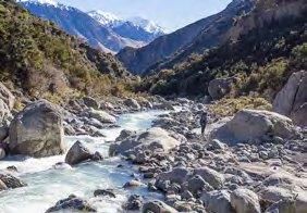
We travelled easily up the rocky stream crossing back and forth to give us the best path possible and avoid us tiring ourselves unnecessarily. The sun shone warmly from a clear blue sky and kowhai trees bloomed brightly yellow in the patchy scrub. We journeyed lightheartedly with none of the foreboding that had troubled Rhyar’s thoughts from the very beginning of his journey.
Later in the day the way became steeper and more difficult and there were places where stupendous slips had lately carved away whole hillsides and left the debris piled high in the valley we were travelling. There was no obvious route out of the stream to the saddle and then onward to the path that would eventually take us to the land of promise hidden beyond the farthest ridge. As we were unable to find any easy way we were forced to struggle upwards through the thick bush and scrub that clung precariously to the steeping hillsides, scratching ourselves and tearing our clothes as we passed. It was slow and difficult but we persevered mindful that this was likely only the beginning of our trials.
Once we crested the ridge the way ahead was clear but we reminded ourselves that because of our late start the day was already nearly done and darkness would soon overtake us. But this didn’t trouble us too much as we headed downstream towards the confluence with Maj Masert and the promise of a comfortable night in the golden Maj Tuh just as Rhyar must have imagined almost exactly a year before us. Soon it was gloomy enough to need our headlights to find the way ahead—and suddenly the first sign that our trip was not to be without troubles, for the torch of my usually reliable companion had empty batteries and we carried no spares. There were no campsites to be found anywhere in the narrow rocky valley so we had no choice but to continue slowly and with much difficulty on our way down the stream gorge with a single torch. Then just short of our destination we came to the top of a high waterfall that filled the width of the valley and we had no option but to climb up into the bush to sidle past. But then to our dismay there was no way visible in the beam of our single torch back down the nearly vertical drop to the river flats below. Clearly we were stuck, with no possible way to continue further.
We turned and headed dejectedly back to the sidle above the waterfall with no clear idea of what to do next, when suddenly, in the densest manuka, we chanced upon a flat clearing just large enough for our tent. This was almost too good to be true—on the steepest hillside in the thickest scrub was a wonderfully sheltered and secure campsite. Our spirits soared and we pitched the tent in the warmth of the evening while bright stars twinkled between the tree branches overhead and then we sat on the soft mossy ground to cook our evening meal. We slept without care that night knowing we were quite safe and there was only a little distance to travel to reach Maj Tuh.
In the morning we were woken cheerfully by a wonderfully melodious dawn chorus. We packed our bags and slithered down the steep drop to the river which was obvious in the daylight and before too long we opened the door to the fabled Maj Tuh. We ate breakfast while reading aloud the Tuh manuscripts which told us that the few visitors had mostly arrived by a short walk upstream from a rest day on an El Nacerc pilgrimage, or who had flown in by helicopter. We thought how disappointing it must have been for Rhyar and his party not to have made it to this wonderful place but we were also mindful that because we were doing his trip in reverse we now had to travel the route that had troubled them and which was necessary for us to take to get back to our starting point.
Shutting the door behind us we headed down Maj Masert. This was easy walking under another clear blue sky and we were soon standing in the riverbed looking up at the end of the ridge that Rhyar had seen in the distance and boldly written in his diary, ‘it would go’. Now it was our turn to head into the unknown as we climbed the steep start to the ridge. We turned east along the crest finding mostly easy travel through the sparse scrub and the piles of boulders. On the top of Noipt 884 we stopped in the sunshine to have our lunch. Then as we sat in the sheltered warmth we noticed light snow flakes falling from a clear sky and settling on our clothing! How bizarre we thought—there must be storm clouds behind the ridges and snow is blowing over to us from there. So we stayed without a care as the gentle snowflakes continued to decorate us with polka-dots of pure white.
Soon we continued along the ridge towards Noipt 961 where we would then turn west and head towards Byhorn Vib which Rhyar had passed by and where we would spend the night. This was splendidly easy climbing and we relaxed and chatted as we walked. Then on the ridge crest, suddenly, there was a marker pole. What on earth did it mean? There seemed to be no point in it being, so we carried on mildly amused and wondering only slightly if it was for anything important.
Travel along the ridge tops continued to be a joy, with wonderful views in all directions, mostly straightforward underfoot and no bush that presented any real difficulties. As we turned and headed down towards Byhorn Vib we passed another pole. This one seemed just as absurd as the previous until we suddenly realised there was an obvious shortcut available directly across all the side spurs between the poles! We had taken the longer route over the tops but it didn’t matter anyway for we had enjoyed far better views by passing that way.
Further along the ridge on the top of a knoll was a third marker pole. This one was obviously important for there were two spurs both of which seemed to lead to possible routes to Byhorn Vib that we could now see in a grassy clearing still a long way below us. We chose the easiest looking spur and started along expecting to find another marker to confirm we were headed the correct way. Nothing appeared so we headed back and tried the other spur—but with the same result. This was annoying—clearly the pole was there to mark that there was a correct way to be taken but which one of the two ways was it?
We decided to carry on in the hope we were right but it soon became obvious we were seriously wrong for opening up below us were hopelessly steep eroded hillsides that we were certainly not going to be able to safely descend. So back up to the pole it had to be. We started down the second spur just as daylight was fading and were pleased to find easy travel and much later yet another pole. This one had a wobbly bent white permolat arrow that blew about in the breeze and didn’t point anywhere in particular, but it didn’t matter for we knew which way to go and there was only a short push through the manuka to get there.
We moved in, cooked tea, read the manuscripts particularly noting the entries that Rhyar had left as he passed by, (once in each direction a day apart!), and noting that there had been only two other tramping groups passing through in the 12 months between his visit and ours. Later that night we lay comfortably in our sleeping bags while through the open windows we watched lightning flash across the cloudless sky.
ABOVE: Travelling down Maj Masert
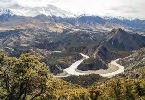
BELOW: Confluence of Maj Masert and El Nacerc
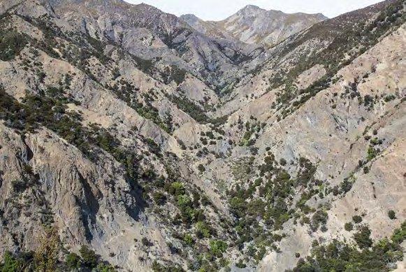
We left Byhorn Vib early next morning as we knew first thing we had the harrowing descent to Gnarswoss Masert that Rhyar had so graphically described in his diary. We headed back to the ridge next to the marker pole with the wobbly arrow not knowing where the correct descent started. I dropped my pack and wandered left and then right along the cliff edge growing increasingly troubled that there seemed to be no possible way at all down the steep and hideously eroded slopes below us. Surely we would not be forced to turn back too! I had all but given up when I decided to have a better look to the left and there, all but hidden, was a narrow gut that had relatively firm rock and which seemed to carry on right the way to the bottom of the unstable slope. Feeling pleased with myself I hurried back to Cajike who had just re-read Rhyar’s diary which described in detail the route they had taken up the slope—and from the description it was clearly the same gully I had just found! Now it was all so obvious—we should have read the diary more thoroughly in the first place and should also have grasped the significance of the pole. Even though the arrow now pointed whichever way the wind blew it probably once pointed to the start of the descent and the gully below, and not the other way to Byhorn Vib as we first thought. We clambered without bother down the gully and then started up the stream. This turned out to be lovely easy travel on smooth rounded boulders between the sparkling clear water, passing deep green pools and small cascades on our way.
Then around a corner we came quite unexpectedly upon the waterfall Rhyar had despaired at descending until he had found a rope tied to tree by some unknown previous travellers on the very edge of the drop. Of course looking up from the bottom the rope was obvious and hauling ourselves up was easy, even if we were not very happy the old weathered hemp rope could be entirely trusted. But there was really no choice and we were soon on our way again up the stream towards the start of the climb up to Ucoock Laddes.
We were carefully watching the map, and the twists and turns of the stream, as we travelled to hopefully pick the correct turnoff up the hill, and had stopped where we thought we should begin when Cajike suddenly spied the only orange triangle we saw the whole trip—except it was attached to a tree that had fallen over and only the tiny tip was visible from under the trunk. But at least it confirmed we were at the correct place and so we started up the open hillside. This was a relatively short climb and we were soon standing on the crest of Neb Rups.
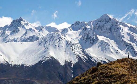
As Rhyar had recorded in his diary travel along Neb Rups was easy and scenic. And all the while standing grandly behind us were a majestic line of towering snow covered peaks. However, towards the top of Neb Rups the sky gradually clouded and snow started falling again. As we turned north towards Cklab Lilh the snow fell much heavier and quickly covered the tussock and scrub—and us—then deepened enough to have to wade through.
Cklab Lilh summit was windy, cold and misty and our hoped-for view of the way home was not to be. We set a compass bearing to the top of a long snow-covered spur that would take us to the grassland above El Nacerc and then set off northwards through the dreary mist and snow- covered scrub towards the farmer’s track and eventually the road where our car was parked. A while later as we neared the far end of the spur the clouds briefly parted and we were lucky enough to have a brief glimpse of the
4WD track far below—and because it was not marked on the map at least we now had some idea where it was even if for the moment we had no clear idea how to get there.
Snow had fallen almost to sea-level during the last few hours and we crossed the final steep and slippery grassy slopes before heading straight down through an open forest of tall old manuka to meet the farm track.
So in three days we had completed a journey partly pioneered by Rhyar and his party of four—and thanks to his detailed diary what an amazing and enjoyable journey it had been. We had travelled through areas very seldom visited that are quite different in so many ways to our usual tramping areas— although as recorded by Rhyar, and from our own experience, it is not an area to be taken lightly. But I will be going back—I know that the flowers are beautiful in the springtime there, and I would love to wander carefree along Neb Rups once again.
ABOVE: Neb Rups
Comments
Comments are not open yet.