
Text taken from the club newsletter.
CYCLING THE WEST COAST WILDERNESS TRAIL by MARILYN ODINOT
Being keen cyclists Peter and I are always on the lookout for new trails to check out. There are plenty around that require a lot of technical ability and a rugged bike with lots of engineering wizardry, and we’ve done quite a few of them in our day. But now we tend to enjoy the gentler trails that cover some beautiful scenery and range around the 40 km a day mark. We wanted to experience a 4-day cycle tour that didn’t involve camping and only needed a couple of panniers of gear each. So, having heard good things about the Wilderness Trail (it’s 139 km from Greymouth to Ross) we decided to take a trip down south and include it in our plan. The trail starts at Greymouth on Day 1 with a night at Kumara, then Day 2 heads inland to Lake Kaniere, Day 3 riding towards the coast and overnight at Hokitika, and Day 4 finishing at Ross.
We packed up the car with tent, bikes, bags and usual accoutrements for adventure and we were off. To maximise anticipation we always have all our gear laid out in the spare bedroom for days in advance. It means you can keep adding to the pile and refining things till eventually it is just right. Then off to the ferry. I adore catching the ferry! It is like going to another country somehow. The South Island is just so different to the North. We headed down to Blenheim and then went inland travelling the Awatere Valley road to get to the Molesworth Station gravel road which gets you to Hamner. This huge high-country station is quite unique and well worth checking out.
http://www.doc.govt.nz/Documents/parks-and- recreation/places-to-visit/nelson-marlborough/ molesworth-brochure.pdf
We had tried to ride our motorbikes through there one summer but it was closed due to high fire risk so it was good to get down there with our bikes to check out the cycling. There are some really lovely DoC campsites along the road so the first night we camped at Molesworth Cobb Cottage. The ranger had some pretty hairy stories about crazy tourists and the accidents they have because they’re not used to gravel roads and sure enough while we were there a panel beater truck came by loaded with a well munted car in need of more than just cosmetic repair! The next morning there was frost over everything but Peter was not deterred and set off up the gravel road for a non-stop relentless hill climb of about 10 km with me quietly driving behind in the truck. We cycled and drove our way to the next DoC campsite at the confluence of the Acheron and Clarence Rivers.
The following day, still on the Molesworth, was again sharing cycling and driving till we reached Hamner for a night. The following day spent at Reefton and finally we reached Greymouth. Staying in the Greymouth Top10 campsite made it very easy to get organised for our 4-day cycle trip. We could leave our car at the campsite there and the trail runs right alongside the camp so it is simple to get a good start on the first morning. We spent a couple of days first just cycling around Greymouth as it is an interesting place with heaps of history and the most impressive river mouth. Definitely worth going there to watch the fishing boats go out or come back in as it is the most incredibly dangerous bit of water with many drownings over the years. It has a poignant memorial that is worth reading. The west coast is notoriously wild and the day before we set off the hard-packed trail along the edge of the beach was covered in a thick very light layer of sea froth that was amazing.
Day 1 (31 km)
The trail has a wonderful mix of scenery. If starting from the Greymouth railway station the trail runs along the side of the huge Grey River then alongside the port and then along lovely sand dunes on the edge of the beach on a good trail that has great views of the sea/ sky interface (commonly known as the horizon). With the salted sea breeze and a beautiful blue sky, the day was a pearler. The trail then passed the occasional lagoon and transformed to a more rural setting. There are areas set up with seating and some excellent information panels that describe the area, history, birds and plants you will come across. At times the trail comes close to the road but there are only very short sections where you are actually on the road. The bridge crossing the lovely Taramakau river has a well-made cycle bridge purpose-built onto it. We were not intimidated by those road sections as we are keen ‘roadies’, but for those who aren’t, it shouldn’t put you off as the road is wide enough to allow plenty of room for safety. Towards the afternoon the trail runs through farmland and some absolutely gorgeous stands of regenerating forest. There is something so elegant about a large stand of young rimu trees with a cycle trail running through it—not a common experience. Since the West Coast is known for its high rainfall it was nice to find that the trail was in remarkably good condition, well packed and draining quickly so even in the rain the trail was good quality.
The first night we spent in a very comfortable renovated cottage run by the Theatre Royal Hotel in Kumara. They were busy building more accommodation there so there are a few options for less expensive stays. There were about 14 giant billboards opposite the hotel that had a superb amount of information about the history of the area. There were some particularly sad stories about miners suffering awful injuries and one about a Chinese market gardener who was treated appallingly by a powerful politician and effectively robbed of his land.
Day 2 (36 km)
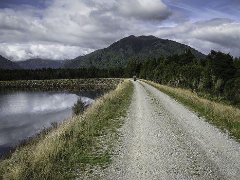
Leaving Kumara you cycle through the back streets of the quiet little village and then divert into a forest with toadstools under pine trees and nice bush. Then you suddenly start coming across giant piles of large boulders all placed on top of each other. These are the mining ‘tailings’ we had heard about but I had never known what it would look like. There were so many of these piles of boulders it was just amazing. All placed and left there to be gradually camouflaged by the encroaching plants. We also made a small side trip to see the seriously massive boulder that had dislodged during sluicing. Apparently, the thud of it landing stopped the Post Office clock. You cycle alongside a couple of lovely reservoirs and see weirs, water races and logging tram tracks (now the trail) and man-made dams. There are wonderful views of the Southern Alps here—with a lacy mantle of mist if you are lucky. There is a nice section of trail that is actually boardwalk and it is surrounded by flax and water. Just gorgeous. There is a neat high suspension bridge that then leads to the final section that involves a little bit of effort with some gentle climbs before reaching Cowboys Paradise. It was on this section that Peter got his first puncture. We had everything we needed for this but it recurred the following day as well so it was good we were well prepared. You are a long way from help and there’s no cell phone coverage!
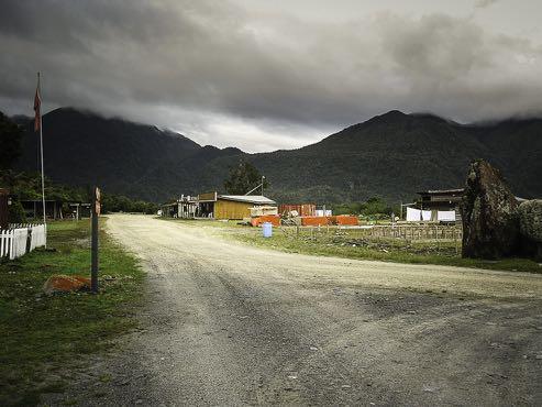
Arriving at Cowboys Paradise you would be forgiven for thinking you had arrived at a recycling depot. It is an un-prepossessing outfit but some punters just love the nature of it. We slept in a unit that was warm and roomy enough but I didn’t sleep happily as I couldn’t stop wondering what dreadful bugs the black sheets were camoflaging. Overnight we heard ruru calling and it was pitch dark outside with a gentle rain falling. The next morning there was a fine mist along the hill tops and as we ate breakfast we heard a roaring stag up in the hills which added quite an ambiance to the place.
Day 3 (36 km)
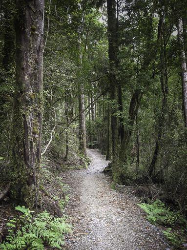
Leaving Cowboys Paradise, you descend on a track that zig-zags for some distance through bush and farm land and in the distance you see the Arahura River leading out to the sea. It is mainly downhill and again riding through some lovely stands of trees. Eventually you reach the breathtakingly beautiful Lake Kaniere where you are suddenly in an area that is more populated and with holiday houses tucked in amongst the trees. It is a nice place to stop for a while. Then leaving the lake you take a sudden dive into an almost secret darkened narrow gap that leads to the start of the water race section. It was hand dug in 1875 and is lined with timber which is still solid. For me this was the highlight as the sound of the running water, the ferns and moisture in the air and the gentle downward slope seemed to lead us into a zen-like space that was truly memorable. Eventually we ended up cycling alongside the water supply pipe for Hokitika and then along a nice rural road where you can see the Kaniere River as you cycle. That night we stayed in a classic really old Hokitika pub where the owners looked after our bikes and made us very welcome. Hokitika has plenty of history as well so if there is enough energy in the tank it’s worth heading to ‘town’ to check out the nearby areas.
Day 4 (33 km)
We needed to get up really early this last day as our plan was to arrive at Ross, the final point, in time to dismantle the bikes and catch the Intercity bus to Greymouth, that comes through once a day at 11:30.
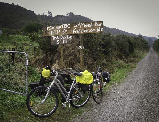
It was pitch dark and raining when we woke up so after a quick breakfast we got out the wet weather gear and lights and loaded up the bikes ready to set off. After crossing the Hokitika River bridge we headed along the outskirts of Hokitika till eventually we came to a long stretch of gravel road that was edged with very high flax bushes which effectively protected us against the worst of the wind that was blowing. At one point there was a nice sign advertising the ‘doctors’ services’. As we continued along past a golf course and various other signs of civilisation we became aware that this last day was probably the least diverse in terms of scenery and interest. The rain was fairly persistent but happily the temperature was quite comfortable. At intervals we came across stands of imperious kahikatea trees which we found particularly interesting. They were in their natural habitat and had the classic straggly, very tall, sparsely branched shape. This last section to Ross was mostly coastal and you certainly got the sense of a really wild west coast environment with the smell of salt, the sound of the crashing surf and many streams that were pouring out to the ocean. There were lots of solid, old, wooden, renovated bridges and at one point I suddenly realised just how vast the amount of water was that was pouring off the hills on our left. So, lots of lagoons and wetlands along there but not much sound of birds as they were hunkered down in the poor weather. There was evidence at times of the massive trees that had been harvested in the early colonial days, with rail tracks and machinery remnants giving a good impression of the size of those regal trees cut down long ago.
Our cycling day ended at the visitor centre at Ross. A sweet little building with an old-world atmosphere about it. There was an incongruous ‘FINISH’ sign there that somehow invited us to ask some tourists to take a photo of us as having completed the trip, something we thought we had ‘grown out of’!
The bus arrived on schedule and because we had dismantled our bikes in advance the driver was happy to take us on board after we quickly stowed our bikes in the baggage area underneath the bus. The trip back took only 1¾ hours and was a good reminder of how much you miss when you travel in a hermetically sealed mechanised capsule.
https://www.westcoastwildernesstrail.co.nz/
Comments
Comments are not open yet.