
Text taken from the club newsletter.
TAPPY
A decent mountain at last by NICK HORRELL
I’d climbed a decent mountain at last’, Ed Hillary said of Tapuae-o-Uenuku (Tappy). Well that settled it for me. Ever since we graduated from our AIC down in Temple Basin last year I’d been reading about the exploits of other keen alpinists, enthralled by the highs and the lows, so cool, so epic. I’d be asked, ‘What’s your plan? What mountains are you actually after?’
Truth be told, I had no idea. I just didn’t like the fact that when winter rolled around Elisabet and I couldn’t jump on the next WTMC trip as it ‘required alpine skills’. I don’t like missing out. So we paid for the course and off we went. After a few alpine trips around the North Island, the obsession grew.
Then I heard about Tappy. A rite of passage, an absolute must for any aspiring mountaineer. A sensible place to start out on our own. So we put together a plan— me, Elisabet and Tereza would go for Tappy on Queen’s Birthday weekend.
The 5 pm InterIslander is packed with familiar faces. We have the company of the WTMC, TTC and NZAC all heading for their long weekend objectives. After an uneventful crossing, we’re off, heading into what feels like the abyss—a desolate SH1 to Kaikoura. They’ve spared no expense on the ‘Road Closed’ warning signs. A ‘blink-and-you-miss-it’ right turn takes us up into the remote Awatere Valley. Almost two hours after leaving Picton, we cross a suspension bridge and park up on a grassy knoll, complete with toilet, where we set up camp for the night.
We wake up to a light frost in the valley, and rise just before the sun creeps over the hills. As we steadily load the gear into the packs, I’m beginning to wonder if I’m just a sucker for punishment for even suggesting we bring harnesses, stakes and hammers. We’d been warned of the need for ropes for the last 20 m by a group the week before and either way it would be good training, right Nick? At 9:30 am, just as we set off, a dusty car pulls up next to us and we are met by Nathan and Nav, who have the same plan. We joke that they’ll soon catch us up with what we’re carrying— we’re not wrong!
After 3 km of farmland a pile of rocks and branches marks the drop off point into the Hodder Valley. We end up taking an awkward route down through thick scrub emerging on the rocky edge of the Hodder River and the first of many crossings. I immediately feel a little claustrophobic—the sweeping cliffs of the valley reach high above me, making it feel quite dark and dank. Luckily for us the river is tame, never more than knee deep. Elisabet and I have opted for Gore-tex trainers, Tereza a second pair of tramping boots.
The valley surprises me with each turn, warm sun traps suddenly become damp and cold gorges, a dead boar a sudden trip hazard, rock falls present Baring
Head style boulder problems, a waterfall forces us up the side of the valley into a rugby scrum of Spaniards. Elisabet has done her homework—80 river crossings. But suddenly we reach number 81—she is mortified, and there’s more!? It’s 2:30 pm and I’m cursing the shoes— my little toe nail is black, I know it. Why did I wear the shoes?
And then they appear. Those two huts perched high up near the head of the valley where the Staircase Stream meets the Hodder. It’s a beautiful sight. As the packs dig into our shoulders we begin the final ascent up 50 m of scree. I’ve never done an approach like it—exhausting yet exhilarating. I’d recommend it.
It’s 4 pm when we finally drop our packs and set about making dinner. The huts are cosy with mould-free mattresses and decent water supplies. We talk weather and summit plans over the trusty Vege Goulash from the WTMC recipe book. At one point Nathan lights up his cooker only for the thing to suddenly erupt into a fiery white spirit hell. The flames break out onto the metal work top. My god we’ve come all this way just to burn down the hut! Quick-thinking Nathan bolts out the door with the cooker in hand and we watch the thing slowly die out from a safe distance.
The front from the south plans to drop by first thing tomorrow so we decide that we’ll check it out at 5 am, and make a call from there. It takes me a while to sleep as the feelings of satisfaction and apprehension battle in my head. My toe nail is in fact black, and it’s throbbing. I can’t summit, not with this pain, not with the wind. Stop it Nick! It’s a bonus, just enjoy the trip. Eventually the tiredness gets me and I’m out.
The alarm rattles my brain at 5 am, and the hut instantly comes to life. We are greeted by a perfectly still valley and a brilliant array of stars. It takes everyone a few minutes to fully digest the fact that if we want the summit we have to leave now as much as our bodies are begging for the warmth of the sleeping bags. A couple of boiling billies later and we are ready to depart.
We start walking at 6 am, and the trail starts out easy enough—meandering up the grassy bank until we reach the huge scree slopes. Or so I am told—our vision extends no further than the circle of light from our head torches. A few slips of rock underfoot a reminder that being sleepy is not an option, alertness and concentration are what’s needed now. After hopping over the river one more time we begin up the Staircase Stream, loosely marked by small rock cairns which are very easy to miss in the dark. As we reach the first terrace the light starts creeping in, enough to turn off the torches.
As we gain altitude toward the head of the valley the trail leading up through the tussock and Spaniard gives way to volcanic rock and lots of it. We lose the rock cairns on more than one occasion, always resorting to heading in the general direction of ‘up’. The going is very slow and the minutes are ticking by—this would be so much easier in the snow! We’ve calculated that we need to find the fourth stream before following it up towards the couloir onto the summit ridge. Upon realising that the third stream just doesn’t exist, we quickly abandon that plan and opt instead for gaining altitude. The cairns long gone, we soon find ourselves out on a steep scree slope which just doesn’t seem like an efficient path. We manage to find shelter from the increasing wind in a small gulley where we layer up and prepare to climb higher. At this point visibility is low and I am seriously doubting our decision to make a break for it early—the forecast promises it will clear up for a short time late morning but I just cannot see this happening. Still, mountains are mysterious beasts.
We eventually hit the snow and decide to switch to crampons and axe. From the first step it’s just perfect— that unmistakable sound as they connect with the crunchy snow. I’m soon in my element, French-stepping up the gully realising this is what I’ve been missing during all the summer.
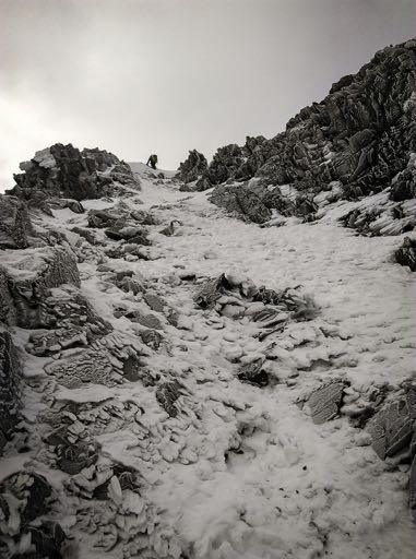
It’s only when I break up over the lip that I realise our drive to gain altitude hasn’t paid off. Ahead of me is an icy bluff as far as the eye can see. Just like some trip reports warned—we’re in the wrong gully! A small snowy opening to the SW beckons, which the GPS suggests will bring us right out on the mouth of the couloir to the top. Traversing 300 m around to the edge of the bluff the couloir opens up above us like a stairway to heaven, and the wind subsides.
We climb higher, switching to front pointing to ascend what feels like the steepest part yet. On arriving at the top we reach a huge basin where we stop for some food under the looming shadow of the route up to WP 2711. It’s here where the SW ridge begins, and a huge rocky outcrop rises up and away from us into the white sky. The summit is still out of view but the air is calm and it’s here that we make the group decision to go for it.
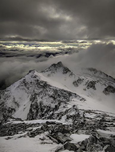
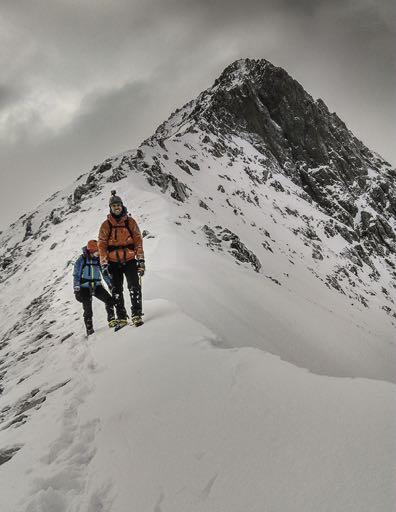
The next 400 m of climbing can only be described as pure excitement. The terrain seamlessly blends frozen scree with crunchy snow with blue ice. Watching every step is a must, picking our way through each obstacle. It’s as they all say—nothing technical, but a challenge nonetheless. It’s a different beast to the North Island mountains we are used to, more raw and gnarly, yet perhaps it’s just because of the time of the year. On we push, sidling rock formations, stalactites from every nook and crevice, corniced ridge lines. With each and every step, the air clears, until there it is, the top staring back at us, within touching distance. A quick glance over to the near vertical south face reminds us of the importance of balance, concentration, awareness.
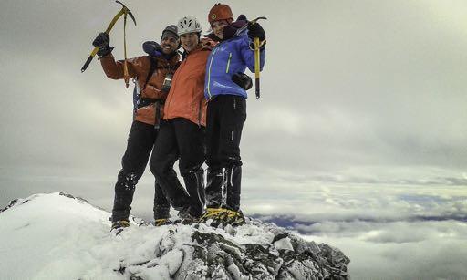
One section necessitates front pointing with a few swings of the axe, just to pull us up over the half metre of frozen scree back to the comfort of the hard snow. Another one, this time a metre high blocks my view, and as I haul my weary legs up over the top and look up I see nothing but sky. The terrain flattens out and I realise that I am standing on the summit of Mt Tappy.
The feeling is immense—a mixture of both sheer joy and trepidation. We’ve done it yet we are only halfway home. Now is not the time to switch off, not yet. It’s 12 noon and the break in the weather we were promised has touched down at the perfect moment. We spy Mt Manukau to the south, Alarm, Mitre, and Pinnacle all around us. Nathan and Nav join us at the top not much later and after a flurry of photos and congratulations we put our game faces back on and begin the descent.
The down climb is every bit as exciting and challenging, only this time the cloud has cleared and we can see the path ahead. Careful movement brings us back down to the basin where we stop for another break, and I devour the very last of my jelly babies.
We finally reach the end of the snow at 2 pm. We’re going slowly now but we don’t mind, we’re in no rush. This time we make sure to follow the direct route down to the stream, where it takes much less time to pick out the trail of cairns leading us home. As we cross the river and begin up the scree slope, the clouds close in and it starts to snow. We bounce our way into the hut at 4 pm, 10 hours after leaving, tired but oh so happy. The hut is quiet by 8 pm, lights out. The wind is picking up outside and the snow coming down now, thick and fast. We know what lies in wait tomorrow—90 river crossings through a very cold and damp valley.
We awake to find snow has blanketed the entire valley. We meander our way back down and over the gorge, eventually dropping into the river. This time we have proper boots and it makes all the difference. After countless hours and crossings, I am snapped out of my zombie-like trance by Tereza disappearing into the bush and up a conspicuous looking mud track. Only then do I notice the familiar looking orange arrow—it can mean only one thing, we’re back on the farmland. The last 3 km along the 4x4 track is the easiest yet hardest I’ve ever walked. We eventually collapse with our packs beside the car and sit in the sun, knowing that the next stop is the pub in Picton and a well earned pint.
Our rite of passage is complete—we’ve climbed a decent mountain.
Comments
Comments are not open yet.