
Text taken from the club newsletter.
EASTER IN THE KAIMANAWAS
A year late but worth the wait by MATT CONWAY with contributions from AIMEE PATERSON and HARRY SMITH
It is always disappointing to cancel a trip, especially one scheduled for a long weekend that provides the opportunity to get out into the hills for an extended period. Also, when you do cancel a trip there is always the nagging doubt aferwards that you could have gone ahead, especially if the weather turns out to be not as bad as forecast.
Tat was the case back in 2017, when I had signed up to lead an Easter trip into the Kaimanawas in conjunction with a fishing trip that Kevin was leading. Unfortunately, that was also the weekend when Cyclone Cook, described as potentially one of the worst storms since 1968, was forecast to make landfall.
Afer plenty of discussion in the days leading up to Easter about what to do, we eventually made the decision to cancel the trips. Te subsequent doubt about this decision arose when the cyclone weakened and turned east afer making landfall, largely sparing the central North Island.
However, it turned out to be the right decision in the long run. Kevin and I decided we would dust off our plans and attempt the same trips a year later in Easter 2018. Fortunately, there didn’t appear to be any cyclones on the horizon this time, and in fact the forecast got better and better the closer we got to the weekend.
So our two groups set off from the railway station on Tursday night looking forward to a mostly fine long weekend in a part of the country that we don’t ofen get to. Our initial plan was to head to one of the campsites dotted along Clements Mill Road, but getting to the end of the Desert Road at around 11:00 pm, with the prospect of at least another 90 minutes driving, meant that we opted for the Waikoko campsite south of Turangi. Tis is a popular spot for freedom campers, but we all managed to find spots to put up tents or flies and got some rest.
Friday dawned clear and still, as forecast. Richard from the fishing group very kindly drove us to Clements Road End. It turned out to take nearly two hours to drive to the road end from the campsite, meaning he did not get the van back to his fishing group until 1.30 pm.
On the drive along Clements Road we passed a number of utes parked in clearings beside the road, a reminder that the roar had started and that we were more than likely to encounter hunters over the weekend, especially with the good forecast. We met one of these hunters at the road-end, who gave us a bit of advice about the track to Cascade Hut, and soon afer 11:00 am we were finally on our way.
It is always a good feeling to get onto the track at the start of a tramp, especially as a trip leader when your focus leading up to the weekend has been on organising the people, gear, food and logistics for the trip. Making it even more enjoyable setting off on this trip were the almost perfect tramping conditions, no wind and sunny and warm—but not too hot.
For the first hour and a half or so on the track it was a pleasant wander along the Hinemaiaia Stream, and I was definitely looking forward to spending the next four days in a forest park that I only visited once before. We stopped for a late lunch in a small clearing just before tackling the only climb of the day, about 450 metres up to point 1240. We knocked this off without too much trouble, and then followed the ridge for a couple of kilometres before dropping down to the Tauranga Taupo River. When we got down to the river there was a bit of confusion about where the track went, back Harry quickly got us back on track, and it was a short half-hour walk to Cascade Hut.
Ofen just before getting to a hut there are questions about how many people would already be at the hut and whether there will be any free bunks. Cascade has six bunks, and with eight of us there was always going to be at least two people on the floor or in tents. Also, with the combination of the Easter long weekend, the fine weather and the roar, the real question was whether there would be any room in the hut at all?
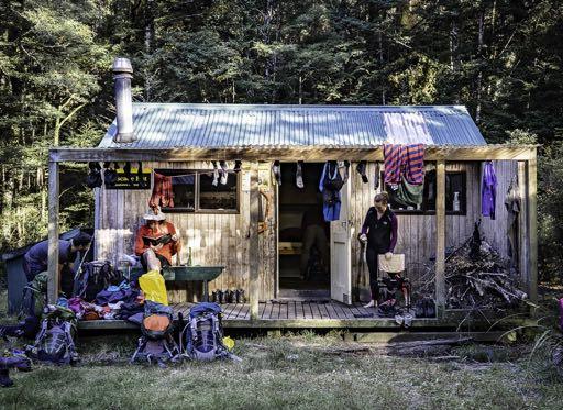
However, much to our surprise we actually had the hut all to ourselves. So, there was plenty of room for everyone to spread out, and pretty soon we had gear and clothing hanging from any available spot around the hut.
Afer a pasta dish from the club recipe book, Tommy and Dan revealed they had brought the entire biscuit aisle with them in their packs, and everyone was feeling pretty full. Despite the temptation to crawl into sleeping bags straight afer dinner, it turned out that Steph happened to be a yoga instructor as well as a physio, and got almost everyone (apart from Harry) involved a yoga session. Feeling a little less lethargic afer the yoga session, Dan and Tommy then introduced as to a game called code master, which took up another hour or so. We eventually retired to bed afer a very satisfying first day’s tramping. No-one else had turned up since we arrived at the hut, and as the other Matt and Harry opted to stay outside in their tents for the night, the rest of us enjoyed a hut to ourselves.
We knew that the second day was going to be the longest one of the trip, with the DoC information saying that it would take around 8-10 hours to get to Boyd Hut, so we were on our way by 8:00 am. Te weather was still calm with just a bit of low cloud around. Setting off we followed the Cascade Stream for a couple of kilometres then climbed 400 m to just over 1,200 m, before dropping down again to Waiatupuritia Saddle. On the way down to the saddle we encountered our second hunter of the weekend. He was sporting some impressive camouflage gear and face paint, and was probably disappointed that we had scared off any deer within a few kilometers, but he didn’t mention it. He did say that was based in Northarm Hut for the weekend, and from the saddle we could see down to Te Waiatupuritia Stream where Northarm Hut is, and just pick out the airstrip next to the hut.
Te stream is in a wide, open river valley which leads down to the Ngaruroro River and Boyd Hut. However, it also happens to be situated in the large block of private land that sits in the middle of the Kaimanawas, so unfortunately we weren’t able to follow what looked like an interesting route to our destination for the night.
Te DoC track follows the ridges around the edge of the private land, and according to the faded sign at the junction where a track goes down to the private land, takes a couple of hours longer to get to Boyd Hut than going along the river valley through it. So we kept going along the DoC track and headed up to Maungaorangi, the highest point we would reach on the trip. Te low cloud had continued to hang around during the morning and I was worried that despite the forecast for good weather we wouldn’t actually be able to see anything from the only point on the trip where we would get above the bushline.
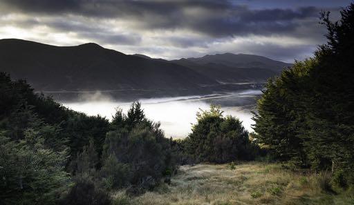
However, the mist cleared just as we got to the top and we were treated to spectacular 360 degree views out over the Kaimanawas and beyond. Behind us we could see down to Lake Taupo, and in front of us to the east we could see the barren-looking tops of the Kawekas in the distance. We spent a bit of time enjoying the views over lunch and then headed on our way.
On a map, the rest of the track looked relatively straight forward, following the ridge for about five kilometres before dropping down the head of the Oamaru River, and then over a small saddle to the Ngaruroro River and Boyd Hut. However, on the ground it was not quite as straight forward, and as Harry put it, “there were lots of annoying little uphill bumps along the way before the final huge, steep descent down to the valley floor”, so it was nearly 5:00 pm before we all finally got down to the track junction by the Oamaru River.
At the junction, there was some debate about camping there for the night. However, this option was quickly dismissed as there were plenty of people in the group keen to keep going, not least Harry who had been trying to get to Boyd Hut for about 20 years. So, we headed up the stream towards Waitawhero Saddle. For me this was the toughest part of the trip. It was only about a 250 m climb up to the saddle, but afer being on the go for 9 hours it felt like a real slog.
We all re-grouped at the top of the saddle, dropped down to cross the Ngaruroro River and then headed up to Boyd Hut, where there was one final obstacle to overcome before the day was over. Boyd Hut is situated about 60 m above the river, so we endured one last climb in what turned out to be quite a long day. Alex and I were the last two to get in by torchlight at 8:00 pm, 12 hours afer we had set off from Cascade.
Tere were other people in the hut, but there were still bunks for all our group. Steph and Tommy took charge of the dinner preparation and produced gourmet peanut satay noodles. Some of us went straight to bed while others managed to stay awake for some more yoga and another round of code master.
Luckily Day 3 was much more relaxed than the previous day, including being able to sleep in for an extra hour thanks to the end of daylight savings. Te track to Oamaru Hut crosses back over Waitawhero Saddle, then follows the Oamaru River down to the hut. So it was a relatively short day with the only climb being back up over the saddle.
Descending back down to the Ngaruroro River, we had more time to enjoy the landscape, afer slogging across it in near darkness the night before.
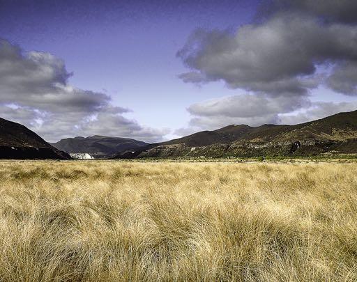
Te Upper Ngaruroro River Valley is a pretty special area. As Harry noted, the wide open tussock-filled valley floor and the broad meandering river feel more like somewhere in the South Island.
In fact, there are moves to get formal recognition of the special nature of this river. A coalition of six groups has recently applied for a Water Conservation Order for the Ngaruroro. Tey believe that the ‘outstanding’ features of the Ngaruroro meet the criteria for this type of protection, which can be seen as the national park equivalent for rivers. Te Environmental Protection Agency is currently progressing the application, and hopefully there will be a positive result soon.
Te Ngaruroro River flows from the Kaimanawas through the Kawekas and then into Hawkes Bay before entering the sea alongside the Tutaekuri and Clive Rivers just south of Napier. It was only afer we got back that I realised that Aimee and I had already visited the Ngaruroro River earlier in the year on a trip into the Kawekas. During that trip we had stopped off at Rocks Ahead Hut for lunch and enjoyed a very welcome swim in the river.
No-one swam in this river on the trip, but we did enjoy spending time on a beautiful autumn morning in a spectacular and relatively remote part of the North Island. Eventually we were on our way, and climbing up to Waitawhero Saddle didn’t seem nearly as bad as the day before and the rest of the day consisted of a nice easy walk along the Oamaru River.
We got to Oamaru Hut at about 3:00 pm. Tere was no sign of the fishing group, but there were a few tents in the large flat area of grass just below the hut which we thought probably belonged to them.
Once again our luck with the huts continued, and in fact there was only one other person there that night. So, we unpacked and headed down to the river for a quick, but very welcome swim. Te fishing group soon re-appeared, without any fish. Tey say that they had caught a couple during the two nights they had stayed in Turangi, but suspiciously didn’t have any proof of this.
Afer cleaning up a few of our group got fishing lessons from Richard before it got dark, but still no-one caught any fish. What Kevin’s group had been able to do in Turangi was buy fresh supplies, so while we ate our freeze-dried or dehydrated meals, they were dining on a gourmet lamb curry.
We did attempt to make up for our relatively modest meals by attempting to finish off the large number of Easter eggs that some of us had been carrying for the whole trip. We mostly succeeded.
On the map, the last day looked like a fairly straightforward wander out to the road end. However, in Aimee’s words ‘it proved a little more difficult than expected’. Te first part of the track crosses the Kaipo River and briefly goes through the bush before coming out onto farm land along an easement through Poronui Station.
Afer Harry got us back on track afer a wrong turn near the start of the farm track, we made reasonably good time to what looked like the end of the track at Taharua Road. However, we discovered that the car park is actually about three kilometres further along the road. So as Aimee said, we had to plod for another hour or more down this gravel road on another hot sunny day before we finally got to the van.
For most of the morning we had seen and heard helicopters buzzing overhead, and when we got to the DoC carpark we could see where they had come from. Right next door was the Heli-Ski helicopter base and there were probably about 30 utes parked there, which explained the constant helicopter activity during the day.
I’m not sure if we felt virtuous having spent the past four days seeing a good part of the Kaimanawas on foot, or envious of people being able to fly in and out—especially afer that morning’s slog along the road.
We didn’t spend too much time dwelling on this, but quickly got changed, back into the van and headed on our way back to Wellington afer a great long weekend.
In summary: Because of the distance from Wellington and relatively restricted access points the Kaimanawas are a destination that WTMC doesn’t get all that ofen. However, it is an area that is definitely worth the effort to get to, with its mixture of beech forest, open ‘South-Islandesque’ landscapes and fantastic scenery.
Having almost perfect weather and a great group of people to travel with also helped make it a memorable weekend and one of my tramping highlights for the year.
Comments
Comments are not open yet.