
Text taken from the club newsletter.
CONDORS AT MY FEET by MIKE PHETHEAN
The acclimatization has gone well. As told in the story by Katy we had spent 12 days going from 4,000 m to 5,200 m. The only down-side was missing the summit of Diablo Mudo but it was not ‘going to go’, so we lived to climb another day.
A day off in Huaraz was supposed to allow me to prepare to go to climb Pisco Ouest (5,760 m), but I got a stomach bug and we lost a few days until I felt well again. I had then intended to climb Copa (6,130 m) but decided to go to Pisco after all.
Logistically it is a much easier climb, there are combies (small passenger vans) and the three hour squashed journey cost me $7. I had not started early, so it was after lunch that I commenced my climb up to the refugio. They are run by a christian charity and all the profits go to helping the poorer locals with housing. Thus I could go with both a lighter pack and conscience—multi tasking!
I arrived about 5 pm having climbed 800 m from the valley floor. The refugio is at 4,650 m and they gave me a welcoming coca tea and as the place was empty I got a room to myself.
An alpine start of 2 am saw me leave at 3 am. I knew roughly where I was heading but my late arrival the previous day prevented me from scouting the route the night before. The way through the moraine is cairned but finding these in the dark was problematic. Eventually I gained a moraine ridge which led me to the glacier edge.
From here the route was obvious, the popularity of the peak means there is a well trodden path. A bit of a weave through some crevasses and I was on the main ridge. The wind picked up making the travel very slow. The snow got blown into deep pockets in which I had to make new deep footsteps, which at altitude is even harder. I reached the summit at 11:30 am and took a few photos before quickly descending. I stopped to chat with some Chileans and Germans— both were finding the route hard work.
Once out of the wind I had lunch and then wearily traversed the moraine somewhat beaten up. I got to the refugio and went to sleep for a few hours before supper. The next day I descended to the road finding a direct bus back to Huaraz. I was happy having made the first summit of the trip and my highest solo climb to date.
A day off allowed me time to meet my guide, Nacho, and pack my bags for the Ishinca Valley. The plan was over 10 days to try and climb four peaks. The Ishinca valley base camp is just one day from the road end. Two of the peaks could be climbed from the base camp and two needed a high camp. However for peaks of this sort of altitude there are few places in the world with such easy access. The base camp is therefore popular but unfortunately neglected by the Huarscaran National
Park. You pay a park fee for every week you climb but 90% of this fee disappears straight into the coffers of the government in Lima. The long drop toilets were falling down and people had to dig pits themselves but being near a stream this is not a long term solution!
The first two peaks went well—Urus (5,495 m) and Ishnica (5,530 m). Both are non-technical and so were a good chance for Nacho and me to sort out our climbing systems. I was starting to feel good, the loss of the first two peaks was now balanced out by three wins.
Next up was the west face of Tocllaraju. (6,030 m). I had a tried to do this in 2008 but had been thwarted by a storm on our summit day. What I didn’t know was that nobody had climbed it since that year. On Urus we had used the fantastic views to decide a route which would minimize our time under the seracs (large ice formations which have a nasty habit of dropping on climbers and killing them) and get us through a rock band. Both were new features since my last visit.
From the high camp we followed the well worn track along the normal route before branching off through knee deep snow to the object of our climb—the west face. The first three pitches were straightforward with the ice axes getting good purchase. The fourth pitch through the rock band was interesting as the snow had melted and sometimes refrozen leading to soft snow followed by ice and then some rock—quite hard mixed climbing!
By now the sun was up and as usual for alpine mountains we changed from kicking our hands and feet to keep them warm by circulating the blood, to wanting a good drink of water. We didn’t want to stop as we were climbing under the seracs and the same heat that was making us thirsty might also destabilize the ice. We pushed on, veering towards the south ridge to stay off the main fall line of the ice above. Three more pitches on some very hard ice, took us to safety and I shared one of my bottles with Nacho. We lunched about another 40 m higher sitting on the apex of the ridge.
In our plans we had thought we would now cruise to the summit but the snow was very soft. It wasn’t just a case of step plugging—sometimes you had to compact the snow so that you could step up on it. Sometimes you just wallowed. It took another three hours to reach the summit—too late for any views as the mist had descended. It was 4 pm and we had left at 2 am, so it was time to switch on because although the north ridge route was well tracked and fitted with someone else’s belay points our tiredness was our enemy.
Three and a half hour later with head torches spotlighting the way we trudged happily into our base camp. Pablo our cook was waiting and presumed we would break camp and drop the two hours down to the valley but Nacho and I stayed. After some welcome soup and pasta, we fell asleep, leaving Pablo to get back to the warmth of base camp—in the state we were in it would have been a risk too far.
Afterwards Nacho let me know we were the first to climb the route for four years. He also raised the grade to TD from D which probably was right—we will let other decide if this is correct when they climb it. Needless to say there were a few enquiries over the next couple of days.
A rest day followed and we learnt that the road out was blocked. There is a local gold mine which has been polluting the head-waters of the rivers. The locals had started protesting about this one and a proposed new one. Peruvians don’t send postcards to politicians, instead they block the road with rocks and just stop anything moving. They also can riot and in a protest later in the year people would die in clashes with the police. The protests only lasted one day on this occasion.
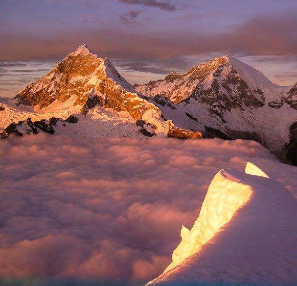
Somewhat obliviously we headed up to the Ranapalca high camp. This is located just below the obvious col between Ischinca and Ranapalca (6,130 m). The sunset was a stunning alpenglow and it was one of the moments that climbing is all about!
We again set off early and followed a trail put in by some Spanish climbers a few days earlier. Running belays took us up the face to the rock band which proved to be quite fun to traverse. I spent ten minutes trying to shout over the top to Nacho to get some slack—he eventually figured it out, hearing my noise but not the detail. We then took some more running belays to the summit plateau. Others had formed a gentle path to the summit and we started on our way before we found some large recently fallen ice blocks across it with the prospect of more to come. It was an easy decision to not go any further. We made good time descending using the snow stakes left by the Spanish. Meanwhile up above, the rock band decided to hurry us along our way by throwing bits of itself on to us! The snow by this stage was very soft and I broke through the crust to my waist too many times. This time we had enough energy and time and carried our camp down to the valley floor. A few beers made the evening go a little more quickly anticipating the trek out to Huaraz the next day.
ABOVE: Inchinca Photos: MIKE PHETHEAN
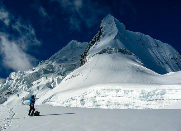
RIGHT: Shaqsha
PREVIOUS: Hauscaraan Sur and Norte, and Chopicalque from Yanapacha
The next peak was Artensonraju (6,020 m), the mountain which features on the Paramount film company’s logo. I had climbed it before by the South East Ridge but this time would attempt it from the North Ridge in the Santa Cruz valley. The valley holds the most popular trekking route in the National Park and is another example of just how poor the National Park Authority are. A few kilometers of the route had been washed away during the winter rains by a massive mud slide and lahar from one of the lakes that used to be in the Artensonraju cirque.
The Park refused to do anything about it, saying that they did not have the money. Eventually the trekking agencies got together and agreed that they would sort the issue out. They paid for a large number of the local donkey drivers to rebuild and remark the track. A higher levy would be charged on any agency trip through that year—the locals were enthusiastic as a lot of their income comes from the tourism. It was great to see such cooperation. Two leisurely days took us to our base camp, from where we hiked across the lahar remains and through some steep wooded meadows to the moraine where we camped just below the glacier. We set off early, weaving our way through a broken-up crevasse field at the bottom of the glacier. As we reached the top of this the mist fell and we climbed to the ridge line too early, the way being blocked by a horrible cornice. A descent and traverse put us back on track and more running belays took us to the summit proper. It was knife edge in places with some quite soft snow so the last section of ridge was interesting. We lunched on the summit as the swirling clouds gave us glimpses of the view around us. We had to put in our own anchors for the descent as there was no evidence of any one else being up that year but we were reasonably quickly back at camp. Some hot soup fired us up and we headed down to the valley stumbling occasionally through the trees and the lahar debris. The welcome lights of base camp guiding us in.
The last time I had climbed Artensonraju it had taken me 18¾ hours and is the longest climb I have ever done it was fitting that this time the whole day was 18½ hours!
I would learn a new mountaineering term when I returned to Huaraz—I think it is American but we were now ‘sending’ which roughly means knocking them off with ease! (I was not so sure about the last bit.)
Fatigue was now catching up with me and the next trip out was a few days on the Yanapacha Glacier. We spent a long time practicing almost every different crevasse rescue, self rescue and all sorts of other climbing tricks. A lot was a good refresher and its aim was so that I would lead Nacho up this mountain.
The plan went well to start with but a combination of waiting for half an hour while some Germans failed to cross the bergschrund in front of us left Nacho feeling too cold. We therefore swapped the lead on each pitch.
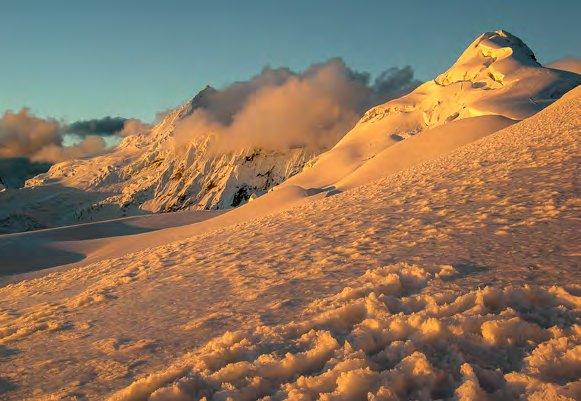
The cold went with the sun coming up and for once the views were breathtaking. Golden snow covered the surrounding mountain reflecting off a base of clouds in the valley. We summited just in time and lingered there snapping the scene before munching a second breakfast.
By now I was just waiting for something to go wrong. Only one mountain to go—Shaqsha Est (5,690 m). The west peak involves crossing a dangerous ice fall so we opted for the east peak which was a bit steeper but relatively safe. This mountain was only an hour from
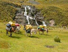
Huaraz and could easily be seen from the roof of my hostel while I had breakfast! Things did not start well— the arrerio (donkey driver) did not show and we then recruited a local to take his place. We then headed off up the tussock hills to our base camp. Stopping for lunch we waited for the donkeys.
And waited... And... About 3 pm we gave up and after some deliberation headed down and arranged a taxi back to town somewhat worried about where our gear was but more worried about the welfare of our cook. We resolved to make an early start and again arranged for a local arrerio. Sure enough as if out of a movie we arrived to find a ponchoed man prancing his horse in the middle of the road. We headed up again and followed a slightly different route (albeit not the one from the guide book.) Just as dawn broke we spotted the cook’s camp on a plateau we had crossed before.
Over eggs and coffee we found out that they had taken the different route, but worse, had gone to the wrong camp site. Reunited and with food to harden our resolve we thought about the peak. The arrerio scrounged some donkeys and we used his horse to take some of the loads too. We headed to the main camp.
Until this mountain we had followed well known trekking routes but up here the trails were faint and more importantly the rubbish was non existent. Our final alpine start led us scrambling over steep moraine before picking up a snow covered ridge to the glacier. A few crevasses needed skirting to reach the main wall. One pitch took us to the bergschrund which though wide had a solid bridge one rope traverse to the right. This, however, meant we had to angle back over to the main route and it was slow work making sure we safely crossed the very soft snow fluting. After this on the main face the snow was extremely inconsistent, hard, then soft and then ice but we made steady progress to gain the top of the face.
We dug some good foot placing and settled down for lunch. Then six rappels took us to the berschund and a good leap got us both safely over that. Then one of those magic moments as a condor glided by below us, my first sighting of a condor from above—sheer beauty. The descent found us reaching the camp at dusk with a great feeling of completeness. I knew that my fatigue was shared—Nacho had originally planned one rest day for himself and then would look for some more guiding work but by now it was at least three!
The next day we walked out quickly and after a good hot shower had a celebration meal and a few beers. There are some that may doubt this but it wasn’t many, I was too thin and too tired to drink properly.
The next day I took the bus to Lima to catch my flight out of Peru and back to another world—I’ll leave you to decide which one is more real.
Comments
Comments are not open yet.