
Text taken from the club newsletter.
FIORDLAND ODYSSEY by AMANDA WELLS
The Wednesday before we left on for our 12-day Fiordland epic, Sharron gave a slideshow on her Westland Christmas adventure. It looked hard. She said that there were times every day when she wished she wasn’t there. It was a comment I often recalled in the coming days...
Why do you spend valuable leisure time doing something so painful that watching television from a couch appears an unobtainable nirvana? After another long Fiordland day, I made the breathless comment to Richard that ‘tramping is full of highs and lows’. Rather than it being an experience of unalloyed joy, as you might imagine a holiday to be, it’s a continual ascent/descent between despairing pits and sublime heights. The highs are hard to explain and sit inside the context of the lows.
On this trip, each day we consciously reflected on our individual ‘best’ and ‘most challenging’ moments. Over the course of the trip there were three standout moments where both of us felt total euphoria. But they won’t make much sense without some background.
We fixed on our route in early December, after some extensive perusal of Moir’s Guide, and a lot of crawling around on a floor full of Fiordland topos. Our hope was to start from Te Anau’s South Fiord (subject to being granted the necessary permit for the takahe protected area) and head through the Murchison Mountains to Middle Arm. We would then go up the Doon River, up Campbell Creek, past Lake Wapiti, down Twin Falls Creek, up the Stillwater and then to Henry Saddle on the George Sound track, with a pick up at Lake Hankinson. From the Doon onwards, we would be following in the footsteps of both a WTMC trip of 2002, and a trip by Richard Davies and Quentin Duthie in 2008. We had printed accounts of both trips, and Richard and Quentin had also made comments on the WTMC trip as they went, so they made for interesting, if slightly intimidating, reading.
Preparing for 12 days in the wilderness somehow consumes more time that you ever thought possible. We dehyed all our own evening meals (doing the same simultaneously for our nine-day Tararua training trip), baked Tararua biscuits and got busy with the vacuum sealer. All of the route notes were combined and retyped in the right order (trying to reverse Moir’s guide directions is an interesting and non-recommended experience) and the logistical loose ends were tied. You always wonder if you’re going to get sick at the last minute, or sprain an ankle, so it was with a sense of relief that we landed in Invercargill one Saturday in early February.
We always knew it was going to be heavy. Twelve days food, plus mountain radio, tent, GPS, beacon and all the other usual essentials. Hauling the packs off the water taxi and on to the beach at South Fiord was unsurprisingly difficult. Steve, our friendly skipper, made the obligatory ‘rather you than me’ comment. And then we were alone. And we stayed alone. We didn’t meet anyone else till we were picked up exactly 11 days later.
The first day was toughened by an accidental 40 minutes uphill. More forgivable than it sounds, because we expected there to be only one orange- triangled track in the area. Once we realised the mistake (a clear ‘most challenging moment’ winner), downhill was at least decidedly more speedy than up. The high point of the day was a lake-clad saddle just on the bushline, with a relatively quick descent to Te Au Hut afterwards. The huts in the Murchison Mountains are set up for DOC use, with some interesting furniture and copious food supplies in sealed containers. We enjoyed the hut book dating from 1980. It’s only relatively recently that conditional public access has been allowed, and the application form requires lengthy description of your suitability and qualifications for wanting to tramp in this special area, which is dedicated to takahe conservation. You must follow a prescribed route, stay in the designated huts, and only one party (of four or fewer) is allowed in the area at a time.
Day two saw us climbing again, up above the bushline to Esk Saddle and then a supposed 2½ hours unmarked climb/sidle/descent to Robin Saddle Hut.
Taking five hours in the baking hot sun was not a high point, though the hut’s amazing location and better-than- expected condition made up for it. For a room without windows, it was surprisingly light and airy, as well as being nicely clean and tidy (like all the huts we visited). The navigation from Robin Saddle to the hut was one of those routes that look satisfyingly impossible from a distance but easy close up.
Next morning we retraced our steps to Esk Saddle (completing the navigation in a still-dispiriting 3½ hours this time) then descended to the Woodrow burn and along to its eponymous hut. Unlike the other, historic huts, this one was new and sported a solar electric light! The evening mountain radio sched was still giving us cheering news about the weather, with rain forecast in a couple of days time but set to clear quickly. We couldn’t believe how hot it was; sleeping bags fully unzipped every night.
Day four was the start of more-intimidating territory. We would be leaving the tracks of the takahe special area and relying on our navigational and bush bashing ability. It was a quick morning down to the Junction Burn confluence, then a bit of time mucking around deciding where to cross. Some maps have an old track marked from the Junction Burn to the Doon but it is definitely gone now. So we followed Moir’s sidle directions to where the Doon turned a sharp corner about 500 m inland.
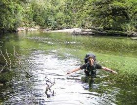
Before the trip we had uncovered a very exciting piece of information: a trapping line had been laid up the true left of the Doon as far as Pisgah Creek. Both the WTMC and Davies/Duthie account expressed difficulty getting up the start of the Doon, so we were very keen to find this new track, which was on the opposite side from the Moir’s route. The Doon is deep, wide and very slow, though the first only became apparent when the knee- deep sandbar I was wading somehow brought water to my armpits. It was an optical illusion, with each step looking shallower but the water getting deeper. I just avoided bobbing downstream and made it across, with Richard coming behind by a marginally less wet route. And then we started to search for the trapping line. I stayed with the packs while Richard ventured inland. We knew the vague plot of the line, Richard having talked to its layer. After a few minutes, an excited shout came back to me. It was unexpectedly one of those moment of sheer happiness and relief that make tramping so alive. We would get up to our destination for the night easily instead of having to grovel through pepperwood. And it turned out that what was supposed to take four or five hours took two.
ABOVE: Crossing the Doon Photo: AMANDA WELLS
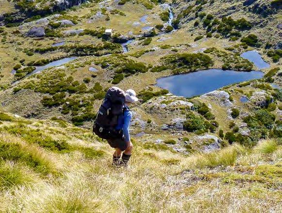
PREVIOUS: Heading down to Robin Saddle Hut Photo: RICHARD LARDNER
But the day had not ended. Crossing back to the Doon’s true right at Pisgah Creek, we went in search of the bivvy rock that both other groups had easily found. We were especially keen to stay there as the rain had started and we figured a rest day would make sense tomorrow. And we couldn’t find it. The Doon is a confusing mass of islands at that point and it took a while to work out where the bank really was. All we knew was that the ‘excellent’ rock was 150 m from the bank and that there was an old line of permolat marking the way. We couldn’t find the markers, so started searching the area. In vain. We checked out a lot of rocks. We did find a sloping rock with very old traces of a fire, but it hardly fit Moir’s ‘excellent’ description. To make matters more worrying, there was a distinct lack of anywhere flat enough to even camp. After 1½ hours, just when things were seeming less optimistic, we decided to cut back to the river bank and again expand the search. And Richard
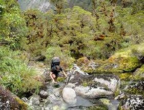
RIGHT: Crossing
Campbell Creek Photo: RICHARD
LARDNER up the north branch of the
OVER: Heading
Stillwater Photo: AMANDA
WELLS saw a pink ribbon in a tree. This was our second ‘yes’ moment of the trip, a rush of relief that was confirmed when we followed the trail of ribbon and permolat to large, spacious rock shelter that kept us dry that night and the next. We did spent some of the rest-day afternoon marking a route from the Pisgah crossing back to the permolat line with orange survival bag strips (good bye sitting mat). Given that the bivvy is actually about 100 m downstream from the Pisgah junction (versus Moirs’ ‘directly opposite’), we felt very fortunate to have made it (grid reference available on request!).
Day six and the packs finally felt less massive. But the section we had worried most about prior to the trip was imminent. Both previous groups had experienced ‘horrendous’ grovels going up Campbell Creek. We kept higher on the true right than I suspect either of them did, and made surprisingly quick time. Thanks to some good terrain awareness by Richard, we managed to cross below the waterfall (which looks slightly less impressive than that description implies), as recommended by Moir’s, rather than boulder-crawl up its true right as the others had. And then things got even easier, with some deer trails and only minor bush bashing. We reached the campsite ahead of schedule—ahead, in fact of Moir’s time! This called for a little celebratory dance by me on arrival. After the debacle of Esk Saddle, to beat a Moir’s time seemed akin to a two-hour marathon. The third of our standout, unexpected, memorable moments. It’s not that the rest of the trip lacked excitement or joy, but just that those three moments reminded me why I do this when the pack is heavy and the bush viciously scratchy. You can’t get that kind of high from a computer.
Naturally it was the navigation that we had not worried about that proved testing. Day seven saw us bleeding through the scrub towards Lake Wapiti, then sidling high above the lake to its head. We reflected on the snow that the WTMC group had endured—we were on to our sixth day of fine weather, if cloudy at times. The difficult-looking pass to Twin Falls creek was an easy and enjoyable piece of climbing and sidling, and the descent mostly lived up to its ‘easy’ description. But we shouldn’t have relaxed so soon. After hitting the main creek, Moir’s recommended descending ‘the creek bed’. Perhaps this was intended to be shorthand for ‘the bush next to the creek bed’ because our attempts to climb down cataracts soon became obviously stupid. Bush bashing was fine but we were a bit grumpy by the time we broke out onto the beautiful flats in the creek’s mid-section.
Going down this flat mid-section the next day was a highlight of the trip: travel was easy and did live up to Moir’s description of wading from one shingle beach to the next. It was good to stop looking at the ground and not get more scratches. But the quick travel meant a relatively quick end to that bliss. We were meant to follow obvious deer trails down the true left of the falls the creek is named for. But something went awry and a little vertical bush bashing ensued before the foot of the falls were gained. We continued up the Stillwater, again fortunate with the weather and resulting low river flows, which meant reaching our forks campsite at 3 pm. Most of the trip, we’d been setting up camp at 5 or even later, so this was a pretty exciting event, especially given that we were on the road by 7.30 am every morning. And we only had one day to go before we rejoined orange markers and could relax a bit.
But that next day was not quite as straightforward as Moir’s implied. Our climb up the true left of the stream gorge must have been too far away from the river, and trying to sidle steep slopes while bush bashing proving a near impossibility. We eventually made the creek bed and gained some time, stopping at what we surmised was Moir’s ‘poor campsite’ for lunch. The tops had been clagged in all morning and we were relieved to see the cloud lift. But it was still hard to interpret where we were supposed to go, and we eventually ended up on the spot height near the southern end of the saddle, after negotiating a slightly tricky ravine. Then it was along the tops, up yet another climb (1,000+m that day, which definitely seems more in Fiordland than it does in the Tararuas!) then down a slightly unobvious descent to Henry Saddle. We were back in the land of triangles. It didn’t matter than some unforecast rain came in that night, nor that we had to pick our way through a bog the next morning. We arrived at Thomson Hut at lunch time and enjoyed an afternoon of rest—and did the same
An advnture is only an inconvienience rightly considered. An inconvienience is only an adventure wrongly considered.
G. K. Chesterton thing next day at Hankinson Hut. We could have gone to George Sound, given that spare time, but the thought of rest was much more appealing at this point.
Watching the float plane come towards us on Lake Hankinson was an exciting end to a gruelling but rewarding trip. I felt much more confident about being off track in Fiordland (and in general), and incredibly thankful for the weather we’d had—only 1½ days of rain in 12. Having to focus so much on every step, and on the navigation, totally clears your mind of everything else, and it had been a total break. Even if we felt in need of some rest afterwards!
Comments
Comments are not open yet.