
Text taken from the club newsletter.
VOLCANO BAGGING
Summiting in the Ecuadorian Andes by EMILY SHROSBREE
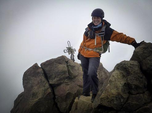
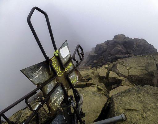
On the summit of Illiniza Norte (5,126 m)
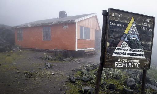
The Nuevos Horizontes Refugio
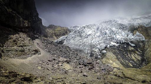
On the Cayambe Glacier at 3:30 am
This journal article documents my wholly scientific research—it’s the story of how I came to know that the inside of clouds look exactly the same the world over.
My research started in the UK with the leisurely self- defined challenge to summit the three highest peaks of England, Scotland and Wales over a three year period. A good proportion of the peaks bagged during this challenge and the surrounding training were in the cloud. Fast-forward to 2013 when I joined WTMC and started tramping in the Tararuas—more views of the inside of clouds from notable peaks such as Hector, Mitre and Holdsworth in Aotearoa, the land of the long white cloud.
By this point I had Northern and Southern hemisphere reference points for my research, but I needed somewhere on the Equator—somewhere with mountains and somewhere that would involve a new adventure for me. I arrived in Quito (2,850 m) with my first three nights of accommodation booked and a whole month to play with. I knew I wanted to get high on a few volcanoes (inside or outside clouds) and spend some time in the Galapagos Islands and that was about it.
My first three days were spent trawling various booking agents to secure the best deal for a week on a boat in the Galapagos and allowing myself to become accustomed to life in a big Spanish-speaking city at 2,850 m above sea level (asl). I’m not sure I ever became ‘accustomed’ to the Spanish-speaking bit, but with the other bits done, I could then focus on fitting in as many volcanic ascents as possible during the remaining three weeks.
First thing was to find a guide I was happy with, and who was happy to take me. Cue more trotting around agencies in Quito talking to potential guides (or their office-based salespeople), inspecting gear and assessing who was offering what. Some agencies were far more optimistic than others in what I would be able to achieve. Some asked questions about my experience and fitness, including whether I was already acclimatised, others just suggested I signed up for their next trip regardless.
I settled on a three day acclimatisation package, guided by Rafael. Rafael was part of an original group of 12 Ecuadorian guides sent to the European Alps 30- odd years ago to be trained. Essentially many of the other guides in Ecuador have been trained by those original 12. Rafael had also been on a number of expeditions in the Himalayas, including guiding on Everest multiple times, and elsewhere in South America AND he had two daughters one of which was the climbing champion of Ecuador and the other who participated in national-level adventure racing, so I seemed to have chanced upon a gem. The conversation went something along the lines of Rafael suggesting, ‘let’s get you acclimatised on this three day trip with three relatively straightforward climbs with no snow involved, then we can both decide if you’re up to one of the bigger volcanoes where we’ll be crossing a glacier and walking up through the night’, and me saying “sounds good”. This sounded like a sensible approach to me and gave me some confidence that this guide wasn’t prepared just to take any numpty up any mountain.
He booked me in for the acclimatisation package, and at the same time offered the opportunity to join a trip to the base of Cayambe (a potential later climb) with a Guatemalan couple the next day. I was itching to get out of the city so signed up to this too. This first trip turned out to be only a short hike up to the Cayambe Refugio (4,600 m) but this was the first time I’d been above 2,500 m in a while so it was a slow one. We had a hot drink in the refugio and then took a detour to explore the bottom of the Cayambe glacier. The streams leading off the bottom of this glacier feed the mighty Amazon which made me gulp as I took in the size and scale of this new continent. Having breathed some more thin air we we went back down to the car and headed back to Quito.
Pasochoa (4,200 m)
A couple of days later, Rafael and I headed off for day one of my acclimatisation tour which involved a relatively easy walk in very Tararua-like country (mist, tussock grass and gnarly ridgelines) to the summit of Pasochoa (4,200 m), a long-extinct volcano. Unbeknown to me at the time this wasn’t to be the only time I would climb Pasochoa.
I was basing all my climbs out of Quito, which meant a fair bit of travelling along the Ecuadorian section of the PanAmerican Highway. Again, some of the scale here was incredible, with huge drops into valleys and big sections cut into the hills for the highway, and huge swathes of agriculture some, like the roses of Machachi, under vast polythene tunnels.
Rafael dropped me off at a guest house somewhere between Pasochoa and Quilatoa which was the next day’s target and then headed back to Quito rather unexpectedly. Feeling a little bit abandoned and with instructions to take it easy and eat well before he collected me at 8 am the next morning I went for a short explore around the very bleak town I had been deposited in, and then enjoyed a good meal before a good night’s sleep.
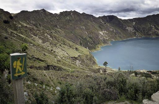
Quilatoa (3,914 m)
Next morning, Rafael appeared promptly to collect me and we drove up into the highlands through the patchwork fields worked by the local Kichwa people. We were already high (around 3,000 m) so I took the opportunity for more acclimatisation with a short walk through the fields.
Then we drove on to the water-filled Quilatoa caldera. This stunning lake can be circumnavigated by kayak rented from the shores of the caldera, or on foot around the crater rim. A little disappointingly, we only had time for the hike down into the crater and back up again, but this at least was a good climb at almost 4000 m asl. With the final, and most challenging, climb of my ‘acclimatisation package’ lined up for the next day, I think Rafael was also quite rightly helping me preserve my energy. We fuelled up on green beans—the local staple—in a basic café near the trailhead.
Later that afternoon I was again deposited at a rather spooky guest house in the village of El Chaupi at the start of the access road to the Illiniza’s. Again instructed to eat and sleep well and to be ready at 6 am for what I understood would be a challenging climb of Illiniza
Norte (5,126m – the 8th highest in Ecuador). Two other climbers who had summited that day were drying out in front of the fire so I quizzed them about how long it had taken them and whether they’d used their ropes (yes, they had, but only for a short section).
Illiniza Norte (5,126m)
6 am the next morning and we were plodding slowly up the flanks of Los Illinizas (the north and south peaks together form the massif), not that we could see them. Our first destination was the Nuevos Horizontes refuge at 4,700m from the road end at 3,900m. Despite several days at altitude I found this climb hard and my stomach was playing up a bit. The clag had come in so I had no sense of our progress and I was very glad to see the refuge after a couple of hours, and even more glad to be presented with a cup of hot tea and some chocolate as I arrived. The refuge was pretty small and grim-looking so I was glad we hadn’t spent the night up there.
Warmed up, refreshed and harness and helmet on, we set off for the summit. The route was a mixture of steep-ish scrambling and scree-sidling and included crossing the ominously named ‘Paso de la Muerte (Pass of Death)’. This was the one time in the trip that I was grateful we were in the clag—I was blissfully unaware of the exposure and just concentrated on remaining sure- footed. We didn’t use any ropes and made the summit within a couple of hours. As I had become accustomed to, the view was again of the inside of clouds. We descended via a large scree slope which was quick but felt a bit hairy on my tired legs, and turned my boots a bright yellow colour. It started to rain as we walked the last half an hour or so to the car. As we set off back to Quito once again, I was pleased to have bagged the second 5,000 m+ peak in my lifetime and already feeling strong enough to broach the subject of a potential attempt on Cayambe after some rest.
Pasochoa (again) and Ruminahui (4,721m)
Back in Quito, I was eager to explore more of Ecuador and set my eyes on Cotopaxi national park which was the home of the currently erupting, and therefore off the list of potential climbs, Cotopaxi volcano (the second highest peak in Ecuador). I spent the next three days chilling out in a nice lodge with views (between the clouds of course) of Cotopaxi. Well, when I say ‘chilling out’, I went mountain biking, had a go at slack-lining and climbed two more 4,000 m+ peaks but the accommodation was very conducive to rest and relaxation being off-grid and with a roaring fire and hearty meals included.
During my stay, I ascended Pasochoa for the second time, this time from the south side and without the clouds. I also bagged Ruminahui (4,721m), again with a cloudy view from the top, but a few condor sightings on the way.
. Cayambe (5,790 m)
Once again back in Quito, having completed the necessary acclimatisation and convinced Rafael I had more fitness and stamina than appearance might seem, he had agreed to take me up Cayambe (5,790 m). I did my best to sleep during the day before—we planned to meet at 5 pm to drive to the mountain, then climb through the night to summit at sunrise—but the pre-climb anticipation was difficult to snooze to. In Rafael’s office I was issued with a pair of La Sportiva mountaineering boots (until then I’d just been in my fairly well-worn tramping boots), a harness, helmet and a set of crampons and Rafael checked all my personal gear was suitable. We headed out of Quito and stopped for some food in the town of Cayambe, where the narrow and bumpy road up to the refuge begins. It was now dark (being on the equator Ecuador has roughly twelve hours of daylight throughout the year) and I slept as we bumped our way up the rugged four-wheel drive track to the refuge. At the refuge we took some time to get wrapped up and prepare gear. In one of the bunkrooms the warden was watching television with the volume up very loud, so once again I was glad we hadn’t opted to spend the ‘night’ at the refuge. As we were getting ready to depart, other climbers were surfacing from no doubt little or no sleep in the noisy, cold and high-altitude refuge. It was around 11pm. There was no cloud and the stars were fabulous. We headed upwards with slow, steady steps for an hour or so before stopping to don crampons. Then we were on to the glacier, and Rafael put me on a rope and gave me strict instructions to walk at the appropriate distance behind him to keep the rope almost taut and above the snow. While I had had some glacier travel training, this was my first experience of walking up the real thing. We plodded on upwards for another couple of hours under the clear sky—it really was a perfect night for climbing. As we got higher, the crevasses got larger and trickier to negotiate. Several times I was instructed to wait while Rafael explored the best way around or across them, and only then could I gently step across the precarious snow bridges. I could tell things were starting to get marginal because each crevasse was taking longer to scope out, and the creaking noises from the glacier were getting louder and more frequent. Sometime around
2:30 am, there was a much larger creaking sound which caused us both to stop in our tracks—I felt like the whole glacier beneath me was about to cave in and take me with it. ‘Stay still’, ordered Rafael, ‘no sudden movements’. Apart from my heart racing, I was definitely not about to make any sudden movements. After a short discussion we agreed it was time to descend as the conditions were too risky to continue up the glacier. Later Rafael explained that recent rains had hollowed out some of the glacier so the crevasses were larger than usual. While I was very happy to be heading down rather than risking being swallowed by the glacier, it was very disappointing to have such a perfectly clear night and not be able to enjoy the sunrise from the summit after a solid couple of weeks of preparation mostly in cloud.
Once we had descended a little to a more solid- feeling part of the glacier I started to look up and out, realising that from here I could see the lights of Quito and all the towns and road networks in between. It was a strange feeling being so high up and on unusual terrain, but yet so close to so much ‘civilisation’. We had made it to above 5,200 m which meant we’d crossed the equator and back during our climb. This is the only place on earth where there is permanent snow on the equator line and you have to be 5 km above sea level to find it! I was once again in awe of the sheer scale of this country.
Rucu Pichincha (4,784 m)
Once again I was back in Quito. Having arrived back from Cayambe in time for a late breakfast, I slept much of the day. But I couldn’t rest too much. I had only two more days until I flew to the Galapagos Islands and still one more peak I wanted to bag. Rucu Pichincha rises straight out of Quito, and has a cable car to get you at least some of the way up. Again, it’s often covered in cloud, especially in the afternoon so I made an early start to maximise my chances of some summit views. As I bought my ticket for the cable car, the attendant checked I really wanted to go given it was cloudy up there— sigh—but yes I did still want to go.
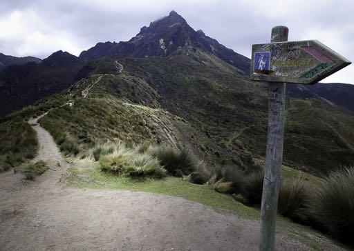
There was a motorway-style path along the ridge above the cable car station leading towards the peak, it sidled round with a couple of tricky scrambles before zig-zagging up a sandy scree slope (which could well have been ash from the 2002 eruption) onto the summit ridge. Despite billing this as the easiest of the climbs I had undertaken and now almost three weeks of acclimatising, it was still surprisingly slow going. Of course, once again I was by now in cloud and my summit selfie could once again have been taken in the Tararuas. On the way down, the cloud around the summit stayed put, but the views across Quito opened out and in the distance I could identify a few of the peaks I had stood atop during the previous weeks.
Islas Galápagos (0 m)
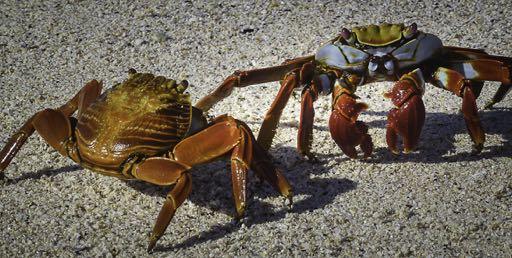
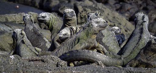
My research complete, I spent my final week in Ecuador very much at, and sometimes under, sea level as I sailed around the Galapagos Islands trying to avoid tripping over the amazingly abundant and curious wildlife. After some physically taxing climbs, the warmth and ease of life on a yacht, with no pestering cloud, was great. Even better was the wildlife which makes it difficult to choose whether the climbing chapter or the sailing and wildlife chapter was the best part of the trip!

Comments
Comments are not open yet.